Iranian Space program | News and Discussions

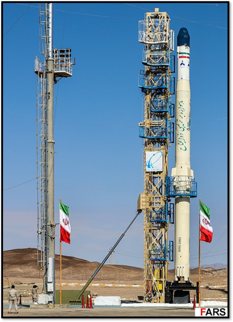
What are the satellite for assuming at least one is for imaging(spy satellite)
they are relatively primitive satellites designed for agriculture mapping and testing IoT technologies

imaging resolution is not suitable for military purposes
 
Successful launch of 3 Iranian satellites into LEO by Russia (7th launch of Iranian satellites into orbit by Russia)

To view this content we will need your consent to set third party cookies.
For more detailed information, see our cookies page.


The satellites were placed into orbit from Russia’s Vostochny Cosmodrome in a multi-payload launch that Iranian officials described as the country’s seventh satellite mission carried out using Russian launch vehicles.

“Two of the satellites belong to the government and one belongs to the private sector, and our knowledge-based companies and universities are active in this field.”

Iranian media identified the satellites as Paya, also known as Tolou-3, Zafar-2, and a prototype satellite called Kowsar-1.5. The spacecraft were launched alongside a large cluster of mainly Russian satellites into a sun-synchronous low Earth orbit.

Paya (Tolou-3), built by the Iranian Space Agency, is Iran’s heaviest Earth-observation satellite to date, weighing about 150 kilograms.

Iranian officials say it is capable of producing black-and-white images with a resolution of about five meters and color images with a resolution of around 10 meters, and is intended for applications including agriculture, water management, environmental monitoring and disaster assessment.

Zafar-2, developed by Iran University of Science and Technology, is also an Earth-observation satellite designed for mapping, environmental monitoring and tracking natural hazards.

Kowsar-1.5 combines imaging and internet-of-things capabilities and is aimed primarily at agricultural and farm-monitoring uses, Iranian officials say.

Jalali described Iran’s space cooperation with Russia as extensive and said Moscow’s experience had played a key role.

“Russia is advanced in the space field, including satellites, launch vehicles and satellite launches, and we have been able to transfer part of the technology and work together,” he said.

Russia also launched Iran's Nahid-2 satellite telecoms satellite (110kg) into orbit in July 2025.
 
Iranian SLV development appears to have ground to a halt in 2025 after a promising 2024, which saw 2 successful launches of the Simorgh SLV place 6 satellites into orbit and 2 successful launches of the IRGC's Qaem-100 SLV place 2 satellites into orbit.

In 2025, Iran did not conduct any (successful) space launches, though there are unverified reports that launches of Zoljanah and Simorgh failed this year and were not reported on.

My Wishlist for 2026:
  • First launch of Qaem-105 SLV (suborbital).
  • First launch of Sarir SLV (suborbital).
  • First successful orbital launch of Zoljanah SLV.
How many satellites do you reckon Iran has? If we count the ones it launched into space + the ones Russia launched into space + Older commercial satellites?
 
It is more plausible than not , the agricultural mapping is a front for the real purpose which is military reconnaissance. It be very silly for both Iran and Russia to admit the real purpose of the satellites.

Not all countries declare military satellite launches. I am sure IRGC has launched numerous satellites without announcing them . How else did they discover the location of IDF AD?

 
Last edited:
Iranian SLV development appears to have ground to a halt in 2025 after a promising 2024, which saw 2 successful launches of the Simorgh SLV place 6 satellites into orbit and 2 successful launches of the IRGC's Qaem-100 SLV place 2 satellites into orbit.

In 2025, Iran did not conduct any (successful) space launches, though there are unverified reports that launches of Zoljanah and Simorgh failed this year and were not reported on.

My Wishlist for 2026:
  • First launch of Qaem-105 SLV (suborbital).
  • First launch of Sarir SLV (suborbital).
  • First successful orbital launch of Zoljanah SLV.
I was going to ask why Iran didn't launch the 3 sats using it's own SLVs but you've answered it.
 
It is more plausible than not , the agricultural mapping is a front for the real purpose which is military reconnaissance. It be very silly for both Iran and Russia to admit the real purpose of the satellites.

Not all countries declare military satellite launches. I am sure IRGC has launched numerous satellites without announcing them . How else did they discover the location of IDF AD?

Plenty of infrastructure in place around the world that continuously monitors anything that reaches space.
 
It is more plausible than not , the agricultural mapping is a front for the real purpose which is military reconnaissance. It be very silly for both Iran and Russia to admit the real purpose of the satellites.

Not all countries declare military satellite launches. I am sure IRGC has launched numerous satellites without announcing them . How else did they discover the location of IDF AD?

No, no, those will be used also for cadastral services. 🤔Like enrichment It is necessary for medical treatments based on radiotherapy. Be sure their pictures will be never used for calculating ranges, guidance, programming seekers and post-hit assessment.
 
  • Like
Reactions: FUB
How many satellites do you reckon Iran has? If we count the ones it launched into space + the ones Russia launched into space + Older commercial satellites?
total number launched into orbit is 20+

but many of them only survived in orbit for 1-24 months and decayed from orbit

right now maybe 10-15 in orbit I guess (lazily)
 
It is more plausible than not , the agricultural mapping is a front for the real purpose which is military reconnaissance. It be very silly for both Iran and Russia to admit the real purpose of the satellites.
with 5-10m resolution, that's not plausible.
 
with 5-10m resolution, that's not plausible.
What makes you think that they have to be transparent like good little boys and disclose everything?
Expert estimates of Noor Sats resolution
  • Noor-1 (2020): ~15–25 meters per pixel
  • Noor-2 (2022): ~10–15 meters per pixel
  • Noor-3 (2023/2024): ~4–8 meters per pixel
To view this content we will need your consent to set third party cookies.
For more detailed information, see our cookies page.
 
Last edited:
it’s been 17 years (2008) since Iran started its space program. Still no reliable launcher and still [periodically] launching micro-sats to LEO. Now it has gotten into a habit of just relying on Russia for launch.

Might be the slowest space program in human history.
 

Milestone in Iran with triple satellite launch​

  1. Politics
December 28, 2025 - 21:5

Paya, Zafar-2, and upgraded Kowsar sent into space from Russia​


TEHRAN – Iran’s space program took a significant leap forward on Sunday as it successfully placed three domestically built satellites into orbit in a single launch, carrying out one of the country's most complex space endeavors to date. The mission has been hailed as a major milestone by analysts and officials.

The satellites—named Paya, Zafar-2, and an upgraded Kowsar model—soared into space atop a Russian Soyuz rocket from the Vostochny Cosmodrome. They are now circling Earth at an altitude of roughly 500 kilometers and each carry their own specialized mission.

The crown jewel of the trio is the Paya satellite. At 150 kilograms, it is now the heaviest spacecraft ever constructed by Iran. Paya carries an imaging camera capable of capturing detailed pictures of the Earth’s surface. Alongside it, the Zafar-2 satellite, developed by a team of university researchers, and the high-resolution Kowsar 1.5 satellite, built by a private Iranian company, round out the payload.

The satellites are designed for civilian use and some of their tasks will include monitoring the country's water resources, tracking environmental changes, managing agricultural land, and aiding disaster response during events like floods and earthquakes.

With its three new "eyes in the sky," Iran aims to build a more robust satellite network. The goal, according to space agency planners, is to be able to monitor any point in the country more frequently, providing data to guide future policy and development.

The successful launch was celebrated at a live-broadcast event in Tehran, where ordinary citizens could apply through the Iranian Space Agency (ISA) social media account to be part of the ceremony. Senior government officials were also present, some of whom stated the achievement was far more than a technical feat; it was, in fact, a crucial step toward self-reliance. Iran’s Minister of Information and Communications Technology emphasized that projects like the ones executed on Sunday were vital for "national management," from connecting remote villages to the internet to combating pollution.

Hassan Salariyeh, the head of ISA, was the next senior official to address the crowd. Some of his remarks pointed to the Iran-Russia collaboration behind the mission, as well as the “maturity” of the country’s space program.

“This success demonstrates the maturity of our knowledge-based ecosystem, as both private sector companies and academic institutions were involved in the projects. For Iran's leadership, the launch serves as a symbol of domestic innovation and technological progress in the face of international sanctions,” he explained.
 

Users who are viewing this thread

Pakistan Defence Latest

Country Watch Latest

Back
Top