34 mothers lay their children's remains to rest again
- Politics
July 22, 2026 - 20:56

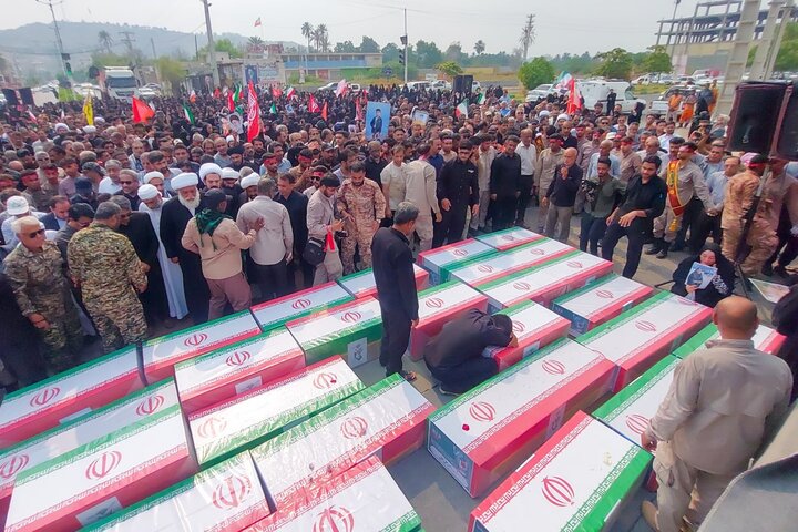
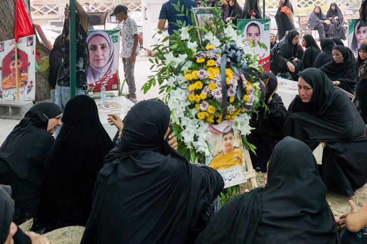
TEHRAN - In a solemn display of grief and defiance, the streets of Minab in southern Iran were draped in mourning on Wednesday as residents gathered to pay their final respects to the young victims of the tragic February 28 US missile strike on the Shajareh Tayyebeh Elementary School.
Nearly five months after the devastating attack that claimed 168 lives—the majority of them young schoolchildren—the community assembled to bury newly identified remains, even as international scrutiny mounts over Washington's refusal to provide a transparent accounting of the tragedy.
The emotional ceremony in Minab, Hormozgan Province, marked the culmination of months of painful recovery and DNA testing efforts. A funeral procession moved toward the city’s Martyrs’ Cemetery, carrying the remains of children whose lives were cut short.
According to provincial officials, 68 body fragments belonging to 34 students were recently identified through precise DNA testing. Among them were the remains of young Amirali Kamali, whose family had waited nearly five months for confirmation.
"Where am I supposed to look for my son?" asked the father of 7-year-old Makan Nasiri in an interview earlier this year, his eyes filled with tears.
Makan, a first-grader, remains the only victim whose remains have not been recovered. Mojtaba Qahramani, head of Hormozgan's judiciary, told Fars news agency that specialized search operations at the school site revealed no trace of the child, as the direct impact occurred precisely where he was standing. An empty grave has been prepared for Makan, while his personal belongings—including a bloodstained sweater and a single sneaker—are preserved in a glass display case at a nearby mosque.
Religious rites and jurisprudence: Honoring the deceased
The recovery and identification process required careful navigation of Islamic traditions to ensure the victims were laid to rest with full dignity.
Ata Navaki, Director General of the Hormozgan Foundation of Martyrs and Veterans Affairs, stated that following consultations with members of the provincial Security Council and the families of the victims, it was decided—with the families' explicit consent—that some of the newly recovered remains would be reunited with the victims' bodies.
Navaki noted that four bodies, despite having sustained severe damage, contained relatively intact remains and were buried separately in designated locations at the Martyrs' Cemetery. Regarding the remaining identified body fragments, it was agreed that they would be interred at a suitable location within the cemetery in a dignified ceremony befitting their sacrifice.
Islamic law places immense emphasis on preserving the dignity and sanctity of the deceased, and the exhumation or disturbance of graves is generally prohibited. Across major schools of Islamic jurisprudence, however, exceptions are recognized in cases of necessity or overriding public interest, such as the recovery of newly discovered human remains, the identification of victims, the protection of legal rights, or the completion of a proper burial. In such circumstances, exhumation is undertaken not to violate the sanctity of the grave, but to fulfill the religious obligation to ensure the deceased are treated with full dignity.
In the Minab case, authorities explained that graves were reopened after the remains of over two dozen students, missing since the February 28 attack, were recovered and identified. The exhumation was carried out strictly to allow these newly recovered remains to be buried alongside their classmates already interred in the same grave. According to Islamic jurisprudence, this action falls within recognized exceptions because its sole purpose is to complete the burial and ensure all identified remains receive a proper and dignified burial in accordance with sacred traditions.
US shirks responsibility for its crimes
The US attack on Shajareh Tayyebeh Elementary School has drawn broad international condemnation. The United Nations Human Rights Office emphasized the right of families to know the truth.
"The families of the little girls who were killed are entitled to the truth of how this happened," stated UN Human Rights Office spokesperson Ravina Shamdasani.
Investigations and prominent coverage by international outlets, including CNN and Sky News, have underscored the severity of the strike, detailing the devastating human toll and highlighting growing questions surrounding the US military's targeting decisions. Despite widespread media exposure and satellite imagery confirming the presence of Tomahawk missile debris at the school site, Washington has faced severe criticism for attempting to evade responsibility.
Months after the strike, the Pentagon has refused to complete a standard intelligence review to establish official accountability. While military assessments completed within days of the attack confirmed US forces struck the school, the final intelligence review—standard procedure for incidents involving mass civilian casualties—was never ordered. Reports indicate senior US military commanders bypassed explicit database warnings that intelligence on Iranian targets was severely outdated, choosing "expediency" over caution as they rushed target lists at the outset of the war.
When pressed in a Fox News interview regarding satellite imagery showing US missile fragments at the site, President Donald Trump suggested the findings might never be made public, claiming "nobody is ever going to be able to say what happened there" and speculating that the imagery could be "AI generated".
In response to the administration's refusal to release findings, more than two dozen Democratic senators submitted a formal demand for answers, writing that "there is no justification for withholding an unclassified accounting of what happened, what went wrong, and what the Department is doing to prevent recurrence."
To honor the memory of the 120 students out of 168 people who lost their lives in the tragedy, local authorities announced that the Shajareh Tayyebeh Elementary School is set to be officially registered as a national site in Iran, serving as a lasting symbol of resilience, sacrifice, and the enduring quest for justice.
US and Israeli military strikes kill Iranian civilians
The tragic strike on Minab occurred directly as a result of the military campaign launched jointly by the United States and Israel on February 28, 2026. From the opening hours of the offensive, waves of precision munitions hit towns and cities across Iran, demonstrating a systematic pattern where US and Israeli forces kill innocent civilians and devastate non-military infrastructure. Rights groups and human rights observers have fiercely condemned the campaign, pointing out how commanders deliberately ignored warnings regarding outdated intelligence and pressed forward with aggressive aerial attacks. The destruction of the Shajareh Tayyebeh Elementary School and the slaughter of 120 young schoolchildren stands as a stark example of how US and Israeli military operations directly target and kill civilians in violation of international law.