Iran reach next level of this war, beyond imagination ... GCC countries are now toy for Iran.
GPS jamming: The invisible battle in the Middle East
7 days ago
Share
Save
Chris BaraniukTechnology Reporter
Windward
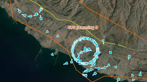
GPS jamming is making ships near the Iranian coast appear to be on land
Hundreds and hundreds of ships. But they're all in the wrong place. "Oh my goodness," says Michelle Wiese Bockmann, senior maritime intelligence analyst at Windward, a maritime AI company, as she checks the live positions broadcast by commercial vessels in waters off Iran, the United Arab Emirates and Qatar.
"I'm up to… 35 different clusters," she says, looking at a map of the Strait of Hormuz and surrounding areas.
The clusters she mentions are weird circles of icons layered over the map, with each icon representing a real ship.
But ships don't bunch together in tight, unnaturally perfect circles. And they also don't hover over land – which is where some of the clusters appear. No, their GPS coordinates have been disrupted, obfuscating their true location.