Pakistan-India Conflict 2025: News Updates and Discussion

Agreed on both.

As the operations were unfolding, ISPR was conducting daily media briefings to bring out facts. All the claims were supported with data. Either physical or digital. Very well conducted I must say.

When the claim of attack on 36 bases was made, I also had no doubt that it is likely to cause a lot of damage. Indian AD is supposed to be better than Pakistan but not so good.

I too was anticipating many deaths and a lot of damage. Next day Col Sophia and her AF counterpart accepted an ATTEMPT to attack many bases but NO substantial damage. I still assumed it to be not true and was expecting images of damage to show otherwise. Many posters claim this statement to be a proof. They don’t seem to understand the difference between ATTEMPT and SUCCESS. India ATTEMPTED against large number of installations. Did it succeed against all? NO.

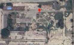
Then satellite images were released by India and I was surprised with the accuracy and the reach of those attacks.
It was now the time for narrative buildup and there was no reason for the ISPR to not come out with their data. Sadly that hasn’t happened till date. If they were so keen to release information to prove their earlier claims, what would stop them from taking the high ground now? Intriguing isn’t it?

After all BuM was all about those attacks and with no proof, there were bound to be many questions.

Then it became clear, that probably the assault against Indian Installations did not really go as planned and envisaged. When India challenged Pakistan to come out with images, it was out of confidence that no major damage has been caused. The reason for ISPR’s silence in this regard started becoming clear. And it was not goodwill or to give an off ramp as claimed by many posters. It was lack of any images, which must have been procured and analysed and then buried deep.

Where did all the Fatah go then? Many of them obviously fell inside many bases and also close to military installations. But that isn’t good enough in these days of hyper-precision. One has to strike a target with precision of a couple of meters to be able to call it a success. Which apparently didn’t happen.

Some of these might have fallen on non-critical buildings or open areas. But it was clear to ISPR that those were not good enough for them to release any official data.

Then what is happening now? There was obviously a lot of questions being raised by critics about lack of success of BuM. What better way to do it then hand it over to media cells of organisations tasked to create narratives. It was given a spark and then it caught up on the social media and many hordes descended over it with Google images. Overnight OSINT experts were ready for the task to the glee and happiness of ISPR.

Very same people were claiming till few days back that India doesn’t allow satellite images of its infrastructure. What happened to that? Till yesterday, poor ISPR was hapless in being able to get images due to Indian hegemony over space?
You see how general population is taken for a ride. No one asked what happened to Chinese brethren who were providing active satellite support on 07 May. Can India stop them from providing these images? The term Fanboys is coined for these situations.

Why do I not accept this effort by so called OSINT? First of all by calling oneself OSINT, one doesn’t acquire the capabilities or tools of this trade.
Many of these X account holders have posted AI edited pictures with non-edited pictures. That muddies the waters. The intent becomes throwing muck and not bringing out facts. Then look at their past account activity. EACH ONE OF THEM, quoted here have been posting propaganda kind of stuff over a long time. That doesn’t give one credibility but takes it away.

Yes, few images do indicate some kind of repair work or renovation in progress. So what? Does that make it battle damage? A credible OSINt needs to get hold of good quality images within few days of the event and then do the analysis.

I have already stated all these earlier but many people are getting sentimental and angry against me.

I have just quoted the minimum required criteria for a credible BDA. And it’s not my fault that ISPR has failed in obtaining this data and laying everything to rest.

I am pretty sure that ISPR would let these amateurs take this narrative to Pakistani awaam and convince them of what they couldn’t achieve.

I am neither buying it nor giving it any credence.
Thank you for giving a detailed explanation. I mostly understand why you think that way with regards to the wad especially with regards to BDA.

However, there are some that I feel are debatable. For analysing satellite images, it is important to also research it yourself. You need to be able to sieve out doctored or AI generated image, which is fairly simply. You just have look for the coordinates and observe it yourself. Then look back before the date to see if the area was targeted. Only if you do your own research (with a neutral lense), would you be convinced about what happened (just like how you agree on the loss of IAF planes, and me on the accurate targeting of PAF runways)

While I agree it's only half of the picture, it still does give you a gauge that those areas were targeted. I do agree that India actually edge out in the land to land conflict due to the precision, damage, and most importantly building the narrative. I have to even go further and say, that they did well to salvage whatever they can.

Pakistan choose to respond back with Operation BuM, but did not provide the necessary evidence. This is what shapeed the mindset of the Pakistani OSINTs. They end up have to find themselves ( I am also guilty of it, largely due to disbelieve that PA did not cause any damage). Some OSINTs did a pretty good job, and some were clutching at straws.

Conclusively, it's up to our own judgements and how we would like to analyse the information presented to us. Nevertheless, I do respect your opinions on OSINTs and understand why you may find them unreliable.
 
You like many others have been trying to find some damage in few of the images. Not all. Just a sliver of hope to get a toe hold then try and carry it forward from there. Cute attempt though.

No critical thinking, no application of logic, just plain effort to create a narrative.

So, you are no different than an average Joe who has gone full bore behind this latest drama.
Trying to find a sliver of hope? Lol Your very own col sophia on record accepted the loss at 5 air bases. I dont need to find anything to catch the liars who are selling the choran that not even a window pane was broken. Its you who are coping, yapping, seething because your ego is shattered.
 
I NEVER MADE OR SUPPORTED THESE. Now you are treading into idiocy along with lying.

You may be head of your nation and this forum and can take responsibility for all the members from your nation, but I don’t.

I talk for myself and my actions.

Can you get back to topic and give some pearls of wisdom about ChatGPT’s analysis of lies that you have been actively supporting?
You really are that dense or willingly obtuse to see my msg? Before you even replied to other poster's msg i told him that the image is AI manipulated but here you are not ashamed of anything at all, lecturing pakistan on a pakistani forum while your chief has been caught lacking and lying.

You call pakistanis liars for sharing manipulated image but you havent said anything about your own chief who is lying through his teeth.
 
This is what Grok has to say about this image.

**Yes, the image in the X post appears to have been modified or generated using AI, or at least digitally altered to falsely depict damage.**
You don't need to rely on the provided image. Use the coordinates, i.e. 30°55'57"N 74°36'08"E as give in the post, in Google maps and see it with your own eyes. Feed that part of the map to Grok to get its analysis. Let's see what you get.

And then don't tell me that Google is lying too.
 
Last edited:
You don't need to rely on the provided image. Use the coordinates, i.e. 30°55'57"N 74°36'08"E as give in the post, in Google maps and see it with your own eyes. Feed that part of the map to Grok to get its analysis. Let's see what you get.
This is what I got from Chat GPT (Question: Please analyze the attached image for damage assessment:).

Based on the satellite image provided, here is a preliminary damage assessment:


🧭

  • The image appears to show an industrial or semi-developed site with scattered structures, some of which seem abandoned or damaged.
  • There is significant vegetation overgrowth, debris, and what appears to be construction or demolition rubble, suggesting partial or full abandonment in parts of the area.

🏚️

  1. Buildings (Top Left & Center-Left)
    • Roofs are partially collapsed or deteriorated (especially the one under the blue tarp).
    • Roof discoloration and irregular shapes suggest possible fire damage, decay, or prolonged exposure without maintenance.
  2. Central Structures
    • Appears to be heavily degraded or in the process of demolition.
    • Large open patches without roofs, and inconsistent wall lines, may suggest partial structural collapse.
  3. Bottom Structures
    • There’s a curved structure and rectangular layout which could be the remains of a foundation or previously roofed building.
    • Surrounding areas are largely filled with debris, indicating heavy destruction or clearance.

🌿

  • Significant overgrowth is visible especially in central and western portions of the site.
  • This overgrowth in and around structures is indicative of neglect over an extended period.

🧱

  • The eastern section is filled with what appears to be construction blocks, rubble piles, or material stockpiles.
  • This can indicate:
    • A demolition site
    • An abandoned construction project
    • Or potentially a storage yard for construction material

🚧

  • Roads are visible but appear dusty and unmaintained.
  • The presence of vehicles or recent activity is minimal, suggesting low or no operational use.

📍 Location Marker:​

  • The red marker is placed on a partially cleared or degraded area, surrounded by overgrowth and rubble, possibly indicating the center of damage or key assessment area.

✅

This area shows signs of:

  • Partial or complete abandonment
  • Extensive structural degradation
  • Possible demolition or halted construction
  • Vegetation encroachment
  • Scattered construction debris or stockpiles

If you need a specific type of damage assessment (e.g., post-disaster, construction evaluation, urban decay, etc.), please clarify, and I can tailor the analysis further.
 

Attachments

  • Destroyed Indian target.png
    Destroyed Indian target.png
    2 MB · Views: 4
Last edited:
To view this content we will need your consent to set third party cookies.
For more detailed information, see our cookies page.


Somebody should fire this abomination who shows up regularly to show how classless and politicized the army leadership has become .

Idiot talks like some Pandoo who is uneducated and washing his dirty laundry in public . Just shows how scared and gutless the leadership has become to be always scared of some one in their custody and kept in isolation.

Inviting enemy to attack may play well for low IQ audience members but anyone with an ounce of brain will understand that yes we can hold our own for a week or two before we buckle without the supply line and finances …. Every idiot knows fighting on two fronts is a suicide except this idiot.

By the way he graduated from Islamabad college where he was bullied and had no friends …. Today he is a spokesperson for ISPR…. UN f … believable
 
Finally one Indian comes out of the delusional psychosis.

But another replying to him is still in psychosis.

To view this content we will need your consent to set third party cookies.
For more detailed information, see our cookies page.
 
Finally one Indian comes out of the delusional psychosis.

But another replying to him is still in psychosis.

To view this content we will need your consent to set third party cookies.
For more detailed information, see our cookies page.

To view this content we will need your consent to set third party cookies.
For more detailed information, see our cookies page.
 

Users who are viewing this thread

Latest Posts

Back
Top