ghazi52
THINK TANK: CONSULTANT
- Mar 21, 2007
- 117,059
- 167,230
- Country of Origin

- Country of Residence

History of Gilgit-Baltistan
Gilgit Baltistan, formerly known as Northern Areas, is a sparsely inhabited area near the northern extremity of the Indian subcontinent, bordering three nations to the east, west, and south: China, Afghanistan, and Pakistan respectively. The Karakoram highway serves as the province’s only commercial route to China. From the Attabad Lake in Hunza to the Deosai Plains near Skardu city, Gilgit Baltistan is a wonder to behold.
In view of its significant water resources, constituting River Indus and expansive glaciers, it is regarded as Pakistan’s water tower and energy hub. Independent communities, however, live in a rugged mountain landscape, serving as an essentially autonomous region. Three of the world’s colossal mountain ranges, namely the Himalayas, the Karakoram, and the Hindu Kush, abut in this region.
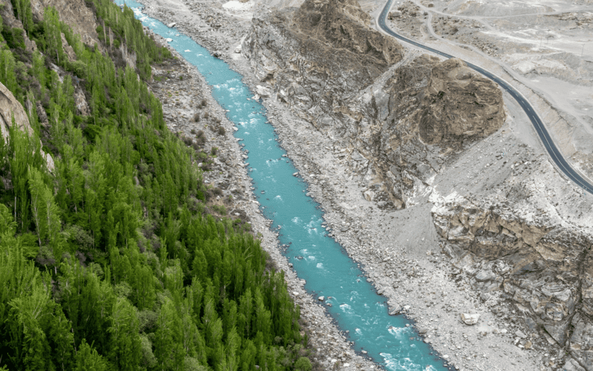
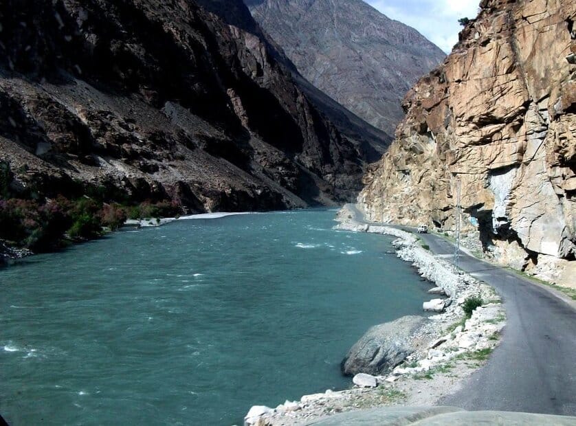
Hunza River and the Karakoream Highway
Due to the region’s isolated, remote position, the extensive geographic diversity found there has resulted in an equally diverse array of biodiversity, ethnicities, and languages. The Himalayan mountainous region of Gilgit Baltistan covers an area of 72, 971 km², six times more than that of Azad Jammu & Kashmir.
Also Read: Rawalpindi Medical University: One of the Best Public Universities for Medical Education
Crammed in nature, snow-clad peaks, galvanic glaciers and rivers, eccentric flora, and exotic cultures, Gilgit Baltistan makes for a great attraction, alluring thousands of people every year. The region splits into the three divisions of Gilgit, Baltistan and Diamer, and is further divided into ten districts.
Similarly, inhabitants in this vast region, Muslims belong to countless groups such as Ismailis, Shiʿite and Shinkaris. Baltis in Baltsitan predominantly follow the Twelver Shiʿite faith, while some Balti intellectuals are attempting to restore Tibetan culture to preserve their original cultural features.
 “
“
En Route – Chitral-Gilgit Rd, Ghizer
Most importantly, the region is rich in natural resources and acts as an important conservation landscape. It accommodates the Himalayan mountain’s last remaining arid conifer forests, dominated by blue pine and chilgoza pine. Besides this, the province is home to a range of glorious and endangered wildlife species such as the snow leopard and the flare-horned markhor.
Other threatened wildlife species in the Gilgit Baltistan area include musk deer, Himalayan brown bears, Himalayan lynx, and leopard cats. Gilgit Baltistan is abundant in mineral resources and yields a variety of valuable radioactive substances. Gold mines are located in numerous areas and riverbeds. While high-quality marble is excavated in Skardu, emerald is mined in Shigar valley. Interestingly, Uranium-238 mines are said to exist there as well.
Prior to its independence, the area of Gilgit Baltistan was once a part of the state of Jammu and Kashmir, one of India’s major princely states. The state of Jammu and Kashmir was established in 1846 with the signing of the Treaty of Amritsar between the British and Gulab Singh of the Dogra Dynasty. The treaty also effectively delineated the southern, eastern, and western borders of a new political entity, pushing the Dogras to the forefront of northern India’s rule.
During the first Anglo-Sikh war, Gulab Singh of Jammu opted to stand with the East India Company (EIC) by remaining neutral. Therefore, the EIC acknowledged Singh’s dedication during the war and thus ‘sold’ the state to him for 7.5 million rupees. Subsequently, Gulab Singh became the first Maharaja of the state.

Jammu and Kashmir’s princely state was divided into four units: the provinces of Jammu and Kashmir as well as the districts of Ladakh and Gilgit. Before signing the Treaty of Amritsar, in 1840, Gulab Singh’s Dogra army attacked and annexed Baltistan. As a result, under the new administrative setup, Baltistan was included in the district of Ladakh.
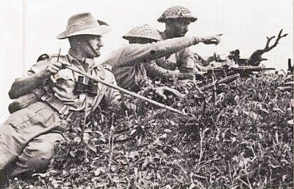
A local paramilitary force was formed and called the ‘Gilgit Scouts’, trained under the directives of the British. The British took over the administration of the Gilgit Agency from the Dogras in 1935 on a sixty-year lease, but the Dogras still ruled Baltistan. The lease was terminated by the British two weeks before Pakistan’s independence.

Kachura Lake, Skardu, Gilgit Baltistan
Major General Scott, the British commander-in-chief of the Kashmir army, arrived in Gilgit with Brigadier Ghansara Singh, the governor of Kashmir then. When the British offered the State of Jammu and Kashmir to take over Gilgit, the governor seized control of the Gilgit Agency from the British, and the Maharaja ruled over the whole province.
Gilgit Scouts were left in the dark regarding their position after Lord Mountbatten abruptly cancelled the lease and transferred power. The Scouts were enraged when it was announced that the force would be replaced by the Kashmir army because they were opposed to the control of the Kashmiri forces.
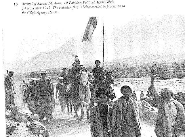
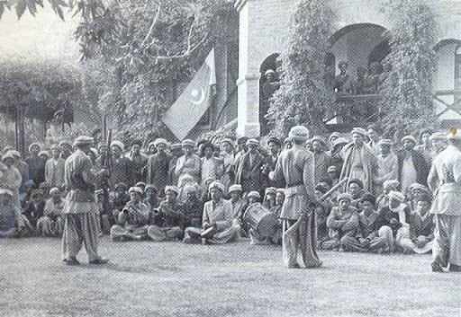
Fearing Muslim uprisings and rebellions in Kashmir, Gulab Singh proclaimed Kashmir’s accession to India. As a result, the Scouts staged a revolt against the Dogras. After considerable struggle, Governor Singh surrendered, and the districts surrounding Gilgit were freed from Dogra control. The Islamic Republic of Gilgit became an independent state on November 1, 1947, and Raja Shah Raees Khan was elected president of the provincial government.

Gilgit acceded to Pakistan ‘unconditionally’ after fifteen days of its independence. Conversely, the Raja of Rondu, Mohammad Ali Khan, gathered everyone in order to confront the Sikh forces that had arrived in Gilgit. During the battle, several troops were slain, while some were captured and imprisoned.
The Scouts were called by the Raja to free Baltistan from the Dogra Raj since there was no organized army in the area. For nearly a year, locals in Baltistan battled with the Scouts against the Kashmir army, costing many lives. Despite the horrors of the past, peace has been achieved in the region. The efforts of Gilgit Scouts that translated into the liberation of the region must be acknowledged and lauded.
Gilgit Baltistan: A Little Piece of Heaven
Palwasha KhanGilgit Baltistan, formerly known as Northern Areas, is a sparsely inhabited area near the northern extremity of the Indian subcontinent, bordering three nations to the east, west, and south: China, Afghanistan, and Pakistan respectively. The Karakoram highway serves as the province’s only commercial route to China. From the Attabad Lake in Hunza to the Deosai Plains near Skardu city, Gilgit Baltistan is a wonder to behold.
In view of its significant water resources, constituting River Indus and expansive glaciers, it is regarded as Pakistan’s water tower and energy hub. Independent communities, however, live in a rugged mountain landscape, serving as an essentially autonomous region. Three of the world’s colossal mountain ranges, namely the Himalayas, the Karakoram, and the Hindu Kush, abut in this region.
Hunza River and the Karakoream Highway
Due to the region’s isolated, remote position, the extensive geographic diversity found there has resulted in an equally diverse array of biodiversity, ethnicities, and languages. The Himalayan mountainous region of Gilgit Baltistan covers an area of 72, 971 km², six times more than that of Azad Jammu & Kashmir.
Also Read: Rawalpindi Medical University: One of the Best Public Universities for Medical Education
Crammed in nature, snow-clad peaks, galvanic glaciers and rivers, eccentric flora, and exotic cultures, Gilgit Baltistan makes for a great attraction, alluring thousands of people every year. The region splits into the three divisions of Gilgit, Baltistan and Diamer, and is further divided into ten districts.
Ethnically & Culturally Diverse
The area’s population is estimated to be 2 million, and it is ethnically divided into two major areas: Dardistan and Baltistan. Local people speak several dialects including Burushaski, Shina and Khowar, which are commonly spoken languages. However, Urdu was adopted in schools following Pakistan’s takeover of these territories.Similarly, inhabitants in this vast region, Muslims belong to countless groups such as Ismailis, Shiʿite and Shinkaris. Baltis in Baltsitan predominantly follow the Twelver Shiʿite faith, while some Balti intellectuals are attempting to restore Tibetan culture to preserve their original cultural features.
En Route – Chitral-Gilgit Rd, Ghizer
Most importantly, the region is rich in natural resources and acts as an important conservation landscape. It accommodates the Himalayan mountain’s last remaining arid conifer forests, dominated by blue pine and chilgoza pine. Besides this, the province is home to a range of glorious and endangered wildlife species such as the snow leopard and the flare-horned markhor.
Other threatened wildlife species in the Gilgit Baltistan area include musk deer, Himalayan brown bears, Himalayan lynx, and leopard cats. Gilgit Baltistan is abundant in mineral resources and yields a variety of valuable radioactive substances. Gold mines are located in numerous areas and riverbeds. While high-quality marble is excavated in Skardu, emerald is mined in Shigar valley. Interestingly, Uranium-238 mines are said to exist there as well.
History of Gilgit Baltistan
The Dogras
Dogri language speakers are an Indo-Aryan ethnolinguistic group known as the Dogras in India and Pakistan. They are mostly found in Jammu and Kashmir as well as the adjacent districts of Punjab, Himachal Pradesh, and northeastern Pakistan. Jammu was ruled by the Dogra Rajputs from the 19th century.Prior to its independence, the area of Gilgit Baltistan was once a part of the state of Jammu and Kashmir, one of India’s major princely states. The state of Jammu and Kashmir was established in 1846 with the signing of the Treaty of Amritsar between the British and Gulab Singh of the Dogra Dynasty. The treaty also effectively delineated the southern, eastern, and western borders of a new political entity, pushing the Dogras to the forefront of northern India’s rule.
During the first Anglo-Sikh war, Gulab Singh of Jammu opted to stand with the East India Company (EIC) by remaining neutral. Therefore, the EIC acknowledged Singh’s dedication during the war and thus ‘sold’ the state to him for 7.5 million rupees. Subsequently, Gulab Singh became the first Maharaja of the state.
Jammu and Kashmir’s princely state was divided into four units: the provinces of Jammu and Kashmir as well as the districts of Ladakh and Gilgit. Before signing the Treaty of Amritsar, in 1840, Gulab Singh’s Dogra army attacked and annexed Baltistan. As a result, under the new administrative setup, Baltistan was included in the district of Ladakh.
Formation of the Gilgit Scouts
Tensions erupted when the British recognized the region’s geostrategic importance and anticipated a Russian takeover from Central Asia. The British intervened by forming the ‘Gilgit Agency‘ to assume control of the province, signifying the start of the ‘British-Dogra’ rule in Gilgit. While the Dogra rulers were in charge of civil administration, the British Indian Empire was in charge of security and military affairs to safeguard its northern frontier.A local paramilitary force was formed and called the ‘Gilgit Scouts’, trained under the directives of the British. The British took over the administration of the Gilgit Agency from the Dogras in 1935 on a sixty-year lease, but the Dogras still ruled Baltistan. The lease was terminated by the British two weeks before Pakistan’s independence.
Kachura Lake, Skardu, Gilgit Baltistan
Major General Scott, the British commander-in-chief of the Kashmir army, arrived in Gilgit with Brigadier Ghansara Singh, the governor of Kashmir then. When the British offered the State of Jammu and Kashmir to take over Gilgit, the governor seized control of the Gilgit Agency from the British, and the Maharaja ruled over the whole province.
Gilgit Scouts were left in the dark regarding their position after Lord Mountbatten abruptly cancelled the lease and transferred power. The Scouts were enraged when it was announced that the force would be replaced by the Kashmir army because they were opposed to the control of the Kashmiri forces.
Road to Liberation
Gilgit and Baltistan were divided into smaller empires governed by local monarchs and elites before and during Dogra rule. Officer ranks were awarded to the governing elites of the empires in the Scouts, affording the Scouts a powerful voice in the region’s future settlement. Revolts against the Maharaja erupted in several parts of Kashmir as British rule loomed.Fearing Muslim uprisings and rebellions in Kashmir, Gulab Singh proclaimed Kashmir’s accession to India. As a result, the Scouts staged a revolt against the Dogras. After considerable struggle, Governor Singh surrendered, and the districts surrounding Gilgit were freed from Dogra control. The Islamic Republic of Gilgit became an independent state on November 1, 1947, and Raja Shah Raees Khan was elected president of the provincial government.
Gilgit acceded to Pakistan ‘unconditionally’ after fifteen days of its independence. Conversely, the Raja of Rondu, Mohammad Ali Khan, gathered everyone in order to confront the Sikh forces that had arrived in Gilgit. During the battle, several troops were slain, while some were captured and imprisoned.
The Scouts were called by the Raja to free Baltistan from the Dogra Raj since there was no organized army in the area. For nearly a year, locals in Baltistan battled with the Scouts against the Kashmir army, costing many lives. Despite the horrors of the past, peace has been achieved in the region. The efforts of Gilgit Scouts that translated into the liberation of the region must be acknowledged and lauded.


