Just to give an idea how hard it is to slip undetected through Malacca strait
 Singapore
 ? No need more explanation, an entire nation's air force and navy is based there. Singapore is US main ally in SE Asia, USN ships usually refuels in SG.
Tanjung Pinang is Indonesian Navy main air base for Western Indonesia with CN-235 MPA and NC-212 MPA
Pekanbaru is Indonesian air force fighter base with currently 2 sqn (F-16/Hawk) soon to be replaced with 2 sqn of Rafale F4. if situation needs, F-16s could be forward deployed to Medan's Soewondo AB or Aceh's Iskandar Muda AB
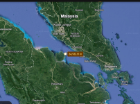
Kelantan is home to RMAF Gong Kedak homebase of the Su-30MKM
GeorgeTown, Penang is home to
Butterworth AB homebase of RMAF F-18 and also co-run with the Australia's RAAF, because Malaysia (Australia and Singapore) is FPDA and Butterworth happens to be HQ of FPDA. There's a possibility if tensions arise RAAF F-35 and F/A-18, E/A-18 will be stationed there or their E-7s
Even if these respective fighters fly in their nation's respective airspace, the wake of such a large PLAN grouping will be detected from afar, if not by the MK1 eyeball than using sophisticated long range FLIR that all air force in the region are equipped with (Thales Damocles, Sniper pod etc)
------------
From top to bottom a PLAN threat assessment would be :
1. Singapore
2. Malaysia
3. Indonesia
- Singapore is as earlier mentioned, a staunch ally of the US,
- Malaysia, even though having differences is part of the commonwealths FPDA,
- Indonesia will simply report the presence of ships of countries crossing the Malacca strait which I bet will find their way to the INDOPACOM by official or un-official means.
IIMS, Indonesian integrated maritime surveillance system dotted the strait, am sure Malaysia has their own as well.
This is what a China Research Ship Yang Hao 2 ship looks like from one of the surveillance system in Sunda strait, similar systems are installed across the Sumatra coast.
And once the PLAN exits the strait, the Indians are waiting.
I simply don't see how the PLAN is sortieing out of the Malacca strait like this. The Japanese Kido Butai only attacks Pearl Harbor using the vast Pacific ocean as cover and using unused sea lanes.
The Malacca strait at its closest distance is less than 40 km across.
This is not to say that China will automatically lose the war, but some comments are so delusional here they need a reality slap.