Old pictures of Pakistani Cities

Indus Flotilla Company

We promise a detailed post on Indus Flotilla Company soon. Today we'll just give a brief introduction about it.

Before the advent of Railways, cargo from Karachi harbor was shipped to rest of India via steamers of 'Indus Flotilla Company'. The steamers took Cargo upto Multan via river Indus and Chenab. This river journey between Karachi and Multan used to take up to 40 days.

Therefore one of the purposes of building Karachi-Kotri railways was to reduce travel times of Indus Flotilla Company. Once Karachi-Kotri railway was completed, Indus Flotilla Company steamers could take cargo from Kotri instead of Karachi and it saved them approx 250km of circuitous journey through Indus River delta.

Look at the map below. It is from 1865 when Karachi-Kotri and Multan-Lahore-Amritsar Railway line was already built. The reason I want to share this map here is to show how the cargo was moved from Karachi to Delhi via rail and river.


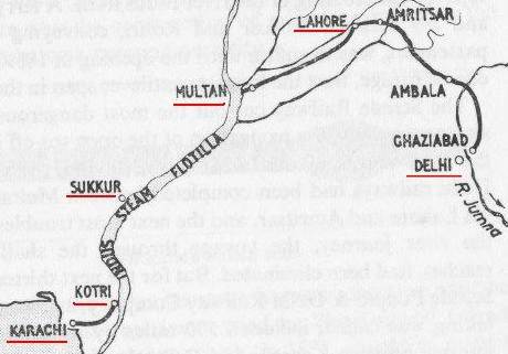
Indus Flotilla Company map, 1865

Gauge Selection for Karachi-Kotri Railway Line

The guage (width) of the railway line was selected as 5'6". It however, narrowly escaped conversion to meter gauge due to high cost of the project.

The reason why the decision was finally made in favor of wider gauge for Karachi-Kotri section was the fact that strong sea breeze blows in this area during monsoon. As there is no natural hindrance, the winds blow with such speed that they pose immense resistance to smaller vehicles. One needs to travel on this route during monsoon to actually feel how strong the winds can be. It has been recorded that strong sea breeze blows on this section on 330 days out of 365 days of a year.
 
Challenges Faced During the Construction

As the construction on Karachi - Kotri section began, the engineers had to face extreme problems which do not exist today. There were no motor trucks, cars or trolleys in those days. Boats and bullock carts had to be used for the transport of rails.

Whenever the chief engineer wanted to go on inspections, a whole congregation had to go with him including men, tents and camels. The average distance they could cover was no more than 15km a day.

Little confidence was reposed in the local people and the British officers moved about armed. The chief engineer John Brunton always carried a brace of loaded revolvers in his belt and a sword by his side.

The contractor, by the name of Brav, got in a lot of trouble. He ran away after 12 months leaving 12,000 workmen unpaid.

Climatic Challenges

The Karachi-Kotri line had to cross numerous water courses which were normally dry, but became raging ******** in the rainy season. Malir river is a good example that floods and cause havocs every few years to this date.

To cut the cost, the engineers did not bridge these water courses and instead laid the railway line on stone filling across the bed of streams. They thought that embankments could be flooded without permanent damage. But the water flow was rapid and the stone dressing was washed away and had to be replaced by bridges.

The climatic features here are quite unique. The average rainfall in this area is approximately 180 mm per year but 90mm of it can fall within a day, therefore flash floods are very common here.
 
Bridges on Karachi-Kotri Section

Thirty two bridges were built on this section to cope with the high rate of flash floods. 25 of these bridges are masonry arched bridges with spans of between 20 feet and 45 feet.

The longest bridge on Karachi-Kotri section is a viaduct of thirty two 45-foot arches across the Bahrun River. Construction on this bridge was started on 5 March 1859 and completed on 26 January 1861.

Another major bridge on this section is the bridge over Malir River which connects Malir and Landhi localities of Karachi.

Locally quarried limestone is used in the masonry of bridges and station buildings on this section.

Cost of Karachi Kotri Railway Section in 1861

All the problems listed above kept raising the cost of Karachi - Kotri railway line and when the project was complete the cost of this railway line came out to Rupees 250,000 per mile. Imagine this cost 148 years ago!

The Inauguration Date

The project was finally completed in 3 years and the 173km long Karachi-Kotri section was opened for rail traffic on May 13, 1861.

Salient Features

Today, the Karachi-Kotri portion of railway line is still one of the fastest speed track in Pakistan with passenger train speeds reaching 120km/h. This portion of railway line also holds the distinction of having the biggest railway yard in Pakistan with 80 railway tracks running parallel to each other near Pakistan Steel Mills. The gradient on some portion of the Karachi-Kotri track is 1 in 200 feet. The curves are no sharper than 43 chains radius.
 
The Original Fencing of Track - It still exists after 158 Years!

The Railway track for its entire length was fenced or walled on both sides and the locomotives were not equipped with cow-catchers. The amazing thing is the portions of this wall built 148 years ago can still be seen on both sides of the track between Karachi and Kotri. Of course at many places it is completely gone but at several places it is pretty intact in the form of limestone wall which is now just couple of feet or less high from the ground.

First Locomotives Used on Karachi-Kotri Section

The first locomotives to be used in and around Karachi and on Karachi-Kotri route were four 2-4-0 tender engines made by Kitson and Co of Leeds in 1858. They had inside cylinders of dimensions 16" x 24" and coupled wheels of 5' 1-1/2".

Seven locomotives which were 2-2-2 'singles' with cylinder dimensions of 15" x 22" and 6-foot driving wheels were supplied by Sharp Stewart & Co in 1859.

In the same year (1859) Sharp Stewart & Co also supplied thirteen more locomotives which were 0-6-0 Goods engines with cylinder dimensions of 16" x 24" and 5-foot coupled wheels.

These engines burned coal. In addition to Karachi and Kotri, water was taken by these engines at Jungshahi (km 91) and Jhimpir (km 124).
 
Karachi - Kotri Railway Map - 1861

The following is the map of Karachi-Kotri track as it opened for rail traffic in 1861. This is a very interesting map. Please take a moment to appreciate the details on this map. Note the 'dotted' hill road shown between Karachi and Kotri is the same alignment as used by the Karachi-Jamshoro Super Highway and future's Motorway M9.

The dotted line shown as lower road to Jeeruk (now called Jhirk) is the present day alignment of the Karachi-Torkham N5 highway. Also note the location of present day Manghopir given as Mugger Pir.

Note the spellings of names of various places which are now pronounced a bit differently.

The Building of Karachi Cantonment Station

Karachi cantonment station when built was called Frere Road Station and served the elite' residential areas of Karachi. Frere road that used to connect Cantonment Station to saddar is nowadays called 'Dr Daud Pota' road. The present building of Karachi Cantonment station was completed in 1898 and currently it has been declared a 'Protected Heritage' by the Government of Sindh.
 
Karachi Cantonment Station in 1930


Railway Stations on the Karachi-Kotri Route

  • Kimari: 0km point on Pakistan's Main Line that runs from Karachi to Peshawar.
  • Karachi City: 5km
  • D.C.O.S (Halt): 7km
  • Karachi Cantonment: 9km
  • Chanesar Goth (Halt): xx
  • Departure Yard: xx
  • Karsaz (Halt): xx - station now closed
  • Air Force (Halt): xx - station now closed
  • Drigh Road Jn: 19km - Junction for Karachi Circular Railway loop
  • Drigh Colony Jn: 21km - Junction for Karachi Circular Railway Loop
  • Malir Colony Jn: 24km - Junction for Malir Cantonment via Matapan & Model Colony
  • Airport (Halt): 25km
  • Malir: 26km
  • Landhi Jn: 29km - junction for Karachi Circular Railway line to Korangi
  • Jumma Goth: 35km
  • Bin Qasim: 43km (previously called Pipri)
  • Badal Nala: xx
  • Marshalling Yard Pipri: xx
  • Gaddar: xx
  • Dabheji: 61km (Last Station of Karachi City Limits)
  • Ran Pethani: 79km
  • Jung Shahi: 91km
  • Braudabad: 108km
  • Jhimpir: 124km
  • Meting: 143km
  • Bholari: 164km
  • Kotri Jn: 174km
 
Remembering the days of Raj

Attock Khurd ................

To the east the Kherimar (Sandal Destroyer) Hills of Attock district rise in a series of jagged crags; to the west flows the Indus in a channel thirty metres below ground level. On the far bank rise the sparsely forested slopes of the Suleman Hills in Khyber-Pukhtunkhwa and to the north and south the face of the earth is divided by the wide channel of the mighty Indus.

In this scenic setting, the doll house railway station of Attock Khurd stands on a low rise a hundred metres east of river’s edge. Its pitched roof with the chimneys and gables, the square pillars from which bell arches spring topped with keystones, and even the gargoyles were clearly designed by someone who valued English country architecture.

This comely building, now festooned with bougainvillea, was left here as a lasting monument and a signature of the designer’s Englishness.

Lying on the main line to the frontier, Attock Khurd was a station for every train to pass through. But lying far from any large urban centre it served a few small villages and forever remained a way station: as the mail and express trains thundered through, only slow passenger trains stopped here.

Few people paused to appreciate its beauty. In Pakistan it became another one of those neglected stations, only good for a fresh coat of yellow wash every time an officer visited on inspection.

In 2007, one hundred and twenty-three years after it was built, Attock Khurd railway station came into the notice of a railway officer with good sense. The building was sand-blasted to reveal a handsome gray stone and brick structure hiding under several millimetres of yellow wash.

The pitched roofs were painted a striking vermillion shade and the east wing of the three-wing building was turned into a sun room with plate glass windows. Relatively unknown Attock Khurd has suddenly become a tourist attraction..........


Lahore , 1860.

مين بازار مزنگ لابود 1860ء

1740758923003.png
 
1987, GT Road through Peshawar City area...

1670426879390.png


Lansdowne Theatre "Falak Sair Cinema" In Peshawar Saddar, 1997 (c).


1670427032616.png


The Lansdowne Theatre, Named The Falak Sair, Was A Mixture Of Gothic And Oriental Architecture, Intricate Stonework And Floral Tiles, Masonry And Woodwork.

This Grand Historic Building Was Sadly Demolished In Peshawar Saddar In 2007 To Build A Shopping Plaza.
© Bernard Perusse
 

Users who are viewing this thread

Pakistan Defence Latest

Country Watch Latest

Back
Top