Pakistan: The Archaeological Marvel

Art work displayed on seals & artifacts of Indus Valley Civilisation of Pakistan provide abundant evidence of fascinatingly imaginative & creative art but nothing related to religiosity. They may have been decorative/illustrate narratives, never displayed symbols of any religion.

1630333640677.png
 
Nangrial in famous Malam-Jaba Valley of Khyber Pakhtunkhwa, Pakistan houses over 2000 years old ancient remains.

Sir Aurel Stein was the first archaeologist to visit the area in 1926. The area houses protohistoric graves, rock art and structures of late antiquity.


1630335238681.png


1630335262379.png


1630335283402.png
 
Mehrgarh..

Located near Sibi in Balochistan, ancient city of Mehrgarh (7000 BC-2000 BC) is the oldest Neolithic human settlement in Pakistan and also in this region with evidence of farming (wheat and barley), herding (cattle, sheep and goats) and proto-dentistry.


7000 BC Mehrgarh city of Pakistan was discovered in 1974 by an archaeological team directed by French archaeologist Jean-François Jarrige, and was excavated continuously between 1974 and 1986, and again from 1997 to 2000.

At its height, the 7000 BC Mehrgarh city of Pakistan is assessed that the population of Mehrgarh city peaked at around 25000 inhabitants and remained continuously occupied till it was abandoned between 2600-2000 BC.

Mehrgarh being the precursor, clearly illustrates a continuous sequence of Indus Valley Civilization’s dwelling sites in Pakistan, established from 7000 BC onwards, highlighting its subsistence patterns, as well as its craft and trade.

Between 7000-6000 years ago people of 9000 years old Mehrgarh, Pakistan learned to use bow-drills, to drill holes in beads of lapis lazuli, turquoise & cornelian etc. They used similar drills in dentistry for drilling in human teeth. Others in IVC, learned it a 1000 years later.


Age-wise Burial of 150 People in 7000 BC Mehrgarh Graveyard, Pakistan:

Uptil 4 years old - 30.79%
5-9 years - 7.15%
10-14 years - 8.15%
15-19 years - 3.13%
20-24 years - 5.35%
25-29 years - 7.72%
30-34 years - 7.89%
35-39 years - 5.51%
40-44 years - 5.68%
50 + years - 15.95%

Metallurgical analysis of copper bead from 8000 years old burial at Mehrgarh, Pakistan allowed recovery of several threads which were identified as cotton. These fibres were earliest known use of cotton & put the date of Ist use of this textile plant back by more than 1000 years.
 
Most houses of 9000 years old Mehrgarh, Pakistan consisted of 4 rooms; 12" wide mudbrick walls. Average structure was 18x12 ft. Rooms generally of same size with small inter-connected/oustide openings. Many rooms/houses were painted red inside and outside, adorned with paintings.


During the excavation of 7000 BC Mehrgarh city, a total of 16 buildings were excavated between 1978-1985. Additional buildings, totaling 46, were excavated in the course of 1997-2000 excavation period. Total area of Mehrgarh city covers 300 hectare.

Jean-Fracois Jarriage who excavated Mehrgarh, states that the paint used for painting the house interiors was prepared from plain red ochre.

Lorenzo Costantini & Alessandro Lentini conducted palynological investigations during 2000s at 7000 BC Mehrgarh in Balochistan, Pakistan. They concluded that climatic conditions were wetter & dense gallery of forests existed at the time in the area till about 4th millennium BC.

Ancient site of Sheri Khan Tarakai in Bannu Basin, Khyber Pakhtunkhwa, Pakistan covers area of 0.2 sq km. It represents a single cultural horizon from over 6000 years, showing parallels with pottery of 9000 years old Mehrgarh & ancient sites in Cholistan & Punjab.

Rafique Mughal

Indus Valley Civilisation was not founded by influences from West Asia. It was indigenous cultural development in Indus Valley region of Pakistan. Excavation of 7000BC Mehrgarh & Naushero revealed long cultural sequence from beginning of agriculture to fading out of Civilisation.

Excavation of several Indus Valley Civilisation sites in Baluchistan, Pakistan areas of Mehrgarh, Nausharo & Pirak etc carried out by French Archaeologist Jean-Franc'ois Jarrige, has revealed a continuous occupation during almost 6000 years, from 7000 BC until 1000 BC.


Ancient farming in Pakistan started from 7000 BC Mehrgarh, located between Sibi and Quetta, in the province of Balochistan. Recent studies have clearly shown that this farming activity was indigenous in nature and did not relate to any movement of ancient Iranians to Pakistan.


Approximately Assessed Population of Ancient Cities:

Jericho (Palestine) - 9000 BC
Population - 2000-3000

Chatal Huyuk (Turkey) - 7500 BC
Population - 5000-7000

Mehrgarh (Pakistan) - 7000 BC
Population - 20000-25000

Jarmo (Mesopotamia) - 6250 BC
Population - 4000-5000

Kachi plains & hills around 9000 years old Mehrgarh city of Balochistan, Pakistan had 12 species of wild animals; gazelle, swamp deer, nilgai, blackbuck, onager, spot
ted deer, water buffalo, sheep, goat, cattle, pig & elephant. Goats & sheep were domesticated animals at Mehrgarh.
 
7th Century Agham Kot/Aghamano founded by king Agham Lohana. It is a ruined city located near Gulab Laghari of Sindh, Pakistan. It is believed that the Indus River used to flow next to the city at one point, making it a vital trade and economic hub for southern Sindh.


1630369253938.png


1630369296255.png


1630369343101.png
 
1630346067272.png


Though coins were found in Peshawar Valley,

Pakistan from 230-200 BC onwards, these were in common use as currency in Swat, Bajaur, Swabi and Mian Khan Sanghou areas of Peshwar Valley from the 3rd century AD onwards.
 
Some data and photographs of fossilised bony remains of saurischian dinosaurs, mesoeucrocodiles, pterosaurs and some footprints and trackways of dinosaurs etc, excavated in Pakistan.


Image


Image


Image


Image
 
1749331460161.png


Portion of platform with steps leading up to dome of Stupa No. 5, Ali Masjid, Circa 1878.

This photograph shows the remains of a Buddhist stupa, including a platform and steps, near Ali Masjid at the head of the Khyber Pass in the North-West Frontier Province (Now Kpk), Pakistan. A stupa is a hemispherical monument which would have formed the focus of worship at Buddhist religious sites such as Ali Masjid.

This photograph shows the site after excavation. It illustrates the type of context that many of the sculptures photographed as part of the Archaeological Survey collection came from. As can be seen towards the bottom of this photograph, each tier of this stupa would have once held small Buddhist sculptures.

Photograph of stupa number 5 taken by Joseph David Beglar between 1878 and 1879; it forms part of the Archaeological Survey of India Collections (Indian Museum Series).

© Joseph David Beglar / British Library
 
1920px-A_Sikh_Monument_in_Rohtas_by_Usman_Ghani.jpg


1920px-Rohtas_Fort_view_of_a_Havelli.jpg


1920px-Rohtas_13_by_Usman_Ghani.jpg


Gurdwara Chowa Sahib (Urdu: گردوارہ چوآ صاحب‬‎; literally: "Gurudwara of the exalted spring") is an abandoned gurudwara located at the northern edge of the Rohtas Fort, near Jhelum, Pakistan. Situated near the fort's Talaqi gate, the gurdwara commemorates the site where Guru Nanak is popularly believed to have created a water-spring during one of his journeys known as udasi.

The first commemorative structure was built by Charat Singh, who installed a sarovar pool, and area for recitation of the Guru Granth Sahib. The current building dates from 1834, and was commissioned by Maharaja Ranjit Singh.

Sikhs believe that Guru Nanak and Bhai Mardana were traveling in the region during the fourth of Guru Nanak's journeys - known as udasis. The two were traveling during the summer, and had arrived at the site following a 40-day stay at the nearby Tilla Jogian temples. Bhai Mardana expressed his thirst while lamenting that water was scarce in the region during that time of year. Guru Nanak is said to have then struck the earth with his cane and moved a stone,thereby revealing a natural spring.

Sikh lore states that Sher Shah Suri attempted to shift the spring up the hill to use a source of water for the newly constructed Rohtas Fort. The king's engineers attempted the feat three times, failing each time.

The gurdwara in 2007, prior to restoration works.
The temple stands at the base of a hill upon which the Rohtas Fort, a UNESCO World Heritage Site, is situated. Despite its proximity to the historic site, the temple is stands disused and neglected, with no local Sikh community to fund its upkeep.
 
Islamabad Museum adds 400 new artefacts to collection

5d756d99b9ef3.jpg


ISLAMABAD: The Islamabad Museum has added 400 new artefacts, including one of two red stone statues of Buddha, Mehergarh pottery and seals from Mohenjo-daro that continue to baffle archaeologists even today.

A chessboard, dice, weights, cosmetics, utensils and many other items have been obtained from the National Museum in Karachi and the Taxila Museum and are now part of the permanent collection at the Islamabad Museum.

The red stone sculpture of Buddhistava, excavated from a site in Badalpur, Taxila, is as rare as the metal sculptures of Buddha found in Pakistan.

“The 2nd to 3rd century red stone sculpture does not have Gandhara features, and was possibly brought here from India,” the museum’s director Dr Abdul Ghafoor Lone said.

Displayed in warm lighting in niches in the wall, every artefact has a unique quick response (QR) code that contains information about it, courtesy of Unesco.

Some of the oldest items of display date back to 4,000 BC, such as a rare dish from Mehergarh, Balochistan, jewellery from Harappa, Punjab, from 2,600 – 1,800 BC and seals and stamps from Harappa from 3,000 BC.

“The script from this period has still not been translated and we do not know what they mean. However, the impressions of deities, bulls and patterns on the seals suggest that they were official purposes and belonged to government departments,” Dr Lone said.

Another artefact on display is a handmade bowl from the 4th millennium BC, which was before the wheel was invented to make pottery.

Besides artefacts from the Gandhara Grave Culture and the Mughal period that have been added to the collection, one of the most attractive pieces on show are two large metal door knockers. Weighing 20 kilograms each, Dr Lone said, the door knockers belong to the Hindu period.

5d756db49d476.jpg


“The Islamic script engraved all around is evidence of how Muslim invaders attempted to incorporate the aesthetics from Hindu cultures into their designs. The door knockers, which were found in Al-Mansura, Sindh, date back to the 8th century AD,” he said.

Housed in the Sir Syed Memorial building near the State Bank, the Department of Archaeology is in the process of expanding the museum’s display area.

“Negotiations are underway and if it works out, we will have a similar large space across the hall to showcase more items of antiquity,” Dr Lone said.

https://www.dawn.com/news/1504287/islamabad-museum-adds-400-new-artefacts-to-collection
 
Ancient city of Bhanbhore: A South Asia gateway for Arab conquerors

1779081-884347581.jpg


This image shows the southern gate of Bhanbhore Fort which was used by Muhammad bin Qasim to enter the citadel in 711 CE. Photograph taken on Sept 25, 2019 (AN Photo by SA Babar)


BHANBORE, Sindh: Bhanbhore, an ancient city located about 65 kilometers east of Karachi, is said to have witnessed several political upheavals since its emergence in the first century BCE. Yet, the place was immortalized by an Arab general who changed the course of history by invading this town.

Long before the mighty Indus river meandered away from the settlement, forcing the residents of Bhanbhore to abandon their dwellings, Muhammad bin Qasim, an Umayyad warrior, defeated Sindh’s Brahmin ruler, Raja Dahar, in 711 CE and conquered large swathes of land. Today, Pakistan’s second busiest harbor, Port Qasim, is named after the Arab general.

5_14.jpg


This image shows the industrial unit where clothes were dyed. “This existence of industrial area, which still needs to be fully excavated, proves that Bhanbhore was an important industrial city in south Asia,” Saleem Palejo, a caretaker of the ancient fort, told Arab News on Sept 25, 2019. (AN Photo by SA Babar)

“The south gate of Bhanbhore Fort from which Muhammad bin Qasim entered the citadel was later called the ‘gateway of Islam’ in South Asia,” Qazi Asif, a researcher, told Arab News.

The first excavation survey of Bhanbhore was carried out by Sindh’s Department of Archaeology and Museums in 1965. More recently, the government launched another round of exploration in 2012 in collaboration with Italian and French missions in Pakistan.

The report detailing the latest findings is yet to be made public. However, a description of the site at the United Nations Educational, Scientific and Cultural Organization’s website says: “The site has a sequence from the first century BC to the thirteenth century AD. Whilst its earlier phases are waterlogged, the site’s surface remains to represent the best-preserved early Islamic urban form in South Asia and the region’s best-preserved medieval port.”

7_11.jpg


Original brick tiles used in Bhanbhore’s Jamia Masjid. Photograph taken on Sept 25, 2019 (AN Photo by SA Babar)

There was no trace of a mehrab – a semicircular niche in a mosque wall indicating the direction of Kabah – but an inscription on a structure, dating to 727 CE, claims that it is the best-preserved example of an early mosque in the region, others having been rebuilt.

“The presence of the industrial sector and the port’s wealth of imported ceramic and metal goods, in combination with its strategic siting at the mouth of the Indus, reinforces the pivotal role of Bhanbhore linking the international Indian Ocean traders with the resources of the interior,” it adds.

Although a French archaeologist, Monique Kervran, says her findings of Bhanbhore confirm that Debal – ruled by Raja Dahar – and Bhanbhore are names of the same place, Dr. Asma Ibrahim, a Pakistani archaeologist, says her research unearthed an underwater city nearby that was most likely Debal.

9_5.jpg


An old well in Bhanbhore Fort. Photograph taken on Sept 25, 2019 (AN Photo by SA Babar)

“The excavation work is still to be carried at the [underwater] city some 12 kilometers from Bhanbhore in the sea where a panel of Kufic inscription – along with one big and one small mosque – has been found,” she told Arab News.
The outline of the underwater city, she added, could be observed between 6 am and 8 pm on the 20th and 21st of a lunar month.

Ibrahim, whose research is yet to be published, informed that the excavated material of glass from Bhanbhore confirmed that it was imported from the Middle Eastern since there was no kiln in this region in olden days.
“It was one of the major industrial and trade centers of the world,” she said, adding: “While the archaeological sites in Bhanbhore await more excavation, there are strong imprints of Arab Muslims.”

https://www.arabnews.com/node/1562861/pakistan
 
The tomb of Baloch leader Mir Chakar-e-Azam Rind and allied Sikh time period walled city.

Officials said Mir Chakar Khan Rind (Chakar-e-Azam) was a Baloch chieftain in the 15th century and considered a folk hero of Baloch people and the most important figure in the Baloch epic ‘Hani’ and ‘Sheh Mureed’. They said in the 15th century, Mir Chakar Khan Rind became the first ruler of Balochistan and established the first Kingdom of Balochistan. He was buried in Satgarah, Okara.


34354548652_1304df1486_b.jpg
 
Buddhist trail goes all across Pakistan so it should cover more than gandhara, there are several buddhist sites in sindh as well.

Thul_Mir_Rukan.jpg


Buddhist stupa in Dadu, Sindh

800px-Gautama_Buddha_statue_%285th_century_CE%29.jpg


Buddha statue from Kahu jo daro, sindh, Mirpurkhas

1024px-Cave_city_Gondhrani.jpg


Godrani buddhist caves in Balochistan.
 
Marvel & mystery

Zarrar Khuhro

IN a rare piece of good news, last week we learnt that France will be returning some 445 relics of the Indus Valley civilisation that were smuggled out of Pakistan over the years and were meant to end up in museums, galleries and private collectors in the West.

The network came to light in 2006, when French authorities intercepted a parcel containing terracotta pots claimed to be about 100 years old. On examination, they turned out to be thousands of years older — burial objects likely stolen from Balochistan. The investigation led to a gallery which yielded even older stolen artifacts as old as 6,000 years — belonging to the Mehrgarh civilisation which was a precursor, or perhaps a part of, the larger Indus Valley civilisation.

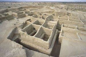
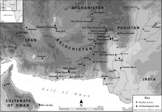
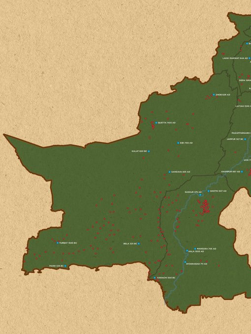
The other piece of good news is that this gives me the opportunity to write about the fascinating Indus Valley civilisation itself. Now, when we usually think of this wonder of the ancient world we think of Moenjodaro and Harappa, and perhaps Mehrgarh. But — and research is constrained here — in actuality the entire civilisation encompassed an area roughly the size of (and perhaps a little larger) than modern-day Pakistan.

The civilisation offers tantalising clues.

Take the archaeological site at Kalibangan in the Indian state of Rajasthan where we find evidence of the world’s first furrowed field. Or Rakhigarha in Haryana which displays the same incredible urban planning — wide roads and an organised sewage system — that is a hallmark of this lost civilisation. Then there is Dholavira in Gujarat which boasts reservoirs that give us a tantalising glimpse into how advanced their water-management system was. Along with this a step-well has been discovered which is said to be three times the size of the Great Bath at Moenjodaro.

Perhaps the most fascinating of these sites is the one at Lothal in the Indian state of Gujarat. In an echo of Moenjodaro, ‘Lothal’ also means ‘hill of the dead’ and is the site of the first known dock in the entire world, which connected Lothal to the Arabian Sea via the Sabarmati river. And this is when it gets really fascinating; as wide as the spread of the Indus Valley Civilisation was, its trade routes went even further, reaching all the way to ancient Mesopotamia in the West, who knew these proto-Dravidians as the ‘Meluhhans’ (the word is likely derived from the Dravidian words ‘mel-akam’ meaning ‘highland country’.

Archaeologist Jane McIntosh writes: “ships from Meluhha docked in Mesopotamian ports; some Meluhhans settled in Sumer; and there is a seal belonging to a Mesopotamian whose job it was to act as an interpreter of the Meluhhan language. On the other hand, there is nothing to suggest that people from Mesopotamia reached the Indus, so it is clear that the Harappans conducted the trade between the two civilisations.”

One major export from the IVC to the West was sesame oil, which was known as ‘ilu’ in Sumerian and ‘ellu’ in Akkadian, and it is likely that this was derived from the Dravidian word for the same, which was ‘el’ or ‘ellu’, another tantalising clue to how interconnected the ancient world was.

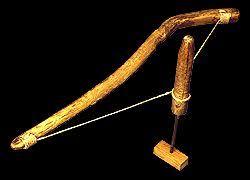
Harappa (near modern-day Sahiwal) also provides clues as to the extent of the trade network, as beads seashells and stones have been recovered from the site, which were not available locally. But perhaps the most incredible find is of a trading outpost located at Shortugai, near the Oxus river near the northern border of modern Afghanistan! From here lapis lazuli was mined and exported to the Indus Valley, and even shipped as far afield as Sumeria. Flourishing trade requires a uniform system of weights and measurements, and indeed a standardised system for such also existed, as did a ruler with measurements marked out in units that resemble modern inches.

We already know of the brilliance of this civilisation’s urban planning, with wide roads, organised housing and a sewage system that was only replicated in Europe in the 18th century. Indeed, were residents of Harappa to take a look at the sewage flooding so many Pakistani towns and villages there is little doubt they would have been appalled.

But what is also notable is that, unlike other ancient civilisations we find little evidence of an organised military, and have yet to discover the great palaces and military murals that were a hallmark of Assyria and Babylon. What is truly unfortunate is that to this day, their script remains undeciphered, and it is unlikely that a Rosetta stone will be stumbled upon, unlocking this great mystery.

Another mystery is that we don’t know exactly how this civilisation perished. There is evidence of invasion, but it is unlikely that this was the leading cause. Indeed, in a grim warning from the past, it seems that climate change may have been the culprit, causing drought and mass migration that led to a collapse of order and, ultimately, civilisation itself. Indeed, here are signs for those who observe.

The writer is a journalist.

Twitter: @zarrarkhuhro
 
1749333410030.png

Temple No. 1 Bhodesar, Tharparkar

Area : 0.2 Acres

Close to the foot of rocky hills there are the remains of three ancient Jain structures supposed to have been built in A.D 1375 and 1449. The largest of this group of temple which is referred as Temple II, stands on a platform about 3’ high and is 39’ wide on the front side which is on the north. It has the main entrance door in the centre and on either side of its two niches on exterior as well as interior.

This door is ordinary (Kanjur) stone and has a jina in a small niche carved over lintal. There were some carved idols on its sides which have decayed and are unrecognisable now. The side niches are of red sand stone with carved DASA, side shafts and head piece and project out of the surface of the walls. Opposite to this door there is another door on the southern side which open in the back courtyard.

This temple is a centrally planned structure with have in the centre and a square aisle around it after which there are two rows of 5 cells each on east and west sides. There are no cells on the north and south but only walls which are similar to each other and have as mentioned earlier a door in the centre and two niches of sides.

The nave is colonnaded with 4 columns on each side and roofed with a corbelled low dome of the shape of an inverted bowl supported on octagonal base of beams resting on eight columns. The floor space under it is square and below the level of the floor of the surrounding aisle and has three steps descending to it from all the four sides. However the huge stones which used to form the floor are now lying in a heap in a shallow pit in centre.

After the aisle there are 5 cell as on each side and opposite to them 5 no the west. In between the doors of these cell as there are pilaster or shafts corresponding to the pillars of the nave. On sides of both the central cell as which are comparatively smaller than side ones there are carved idols on pedestals typical of the Jaina temples.

On the outside there is a double cornice running on the east west and northsides except the central portion of the front wall and entire south wall which have been repaired in the past. The incomplete wall on the east measures 40.5’ where as the west wall measures 31.5’ which indicates that there was back enclosure on the south side probably with a central cell or inner temple for housing the main idol but has disappeared in course of time.

On the roof there is a central dome of the nave and around it 16 domes of the aisles and 10 more domes of the tow rows of the cells which makes in all 27 domes. From inside some of these small domes are corbelled in circular fashion and some in diagonal patterns From outside the entire roof including the domes have been plastered with white lime, in thick layers. Along the eastern side of this temple there was an enclosed portion attached as shown by the low compound wall of rubble stones.

All stone used in the temple in Kanjur stone and red sandstone which are not local. However, the stone used in the platform and the attached compound wall is local sand stone or granite of red tint .
 

Users who are viewing this thread

Latest Posts

Back
Top