Chinese Missile News

Last edited:
This design probably would I serve better as a survivable offensive system. Besides, how different is this from some GDI concepts, except this is an endoatmospheric interceptor? KEI interceptor meant to be carried in the Zumwalt’s Mk.57 large VLS tubes? Btw, from its dimensions, is it meant to be carried by the Type 55 and Type 52D destroyers?


I thought they canceled the multiple-kill vehicle a long time ago. It is vaporware! The US has no defense against MARV or Hypersonic missile

The Multiple Kill Vehicle (MKV) was a planned US missile defense program to develop small warheads that could destroy multiple ballistic missiles and decoy targets. The program is expensive and has not been implemented.
 
Take Patriot’s performance in Saudi Arabia for example, between 2015 and mid 2019, Patriot batteries in Saudi service intercepted more than 230 Iranian ballistic missiles – that’s more than 1 intercept every week and highlighted the volume of ballistic missile they faced. By 2021, Saudi Arabia reported Houthi firing 430 ballistic missiles and 851 drones in 6 years that resulted in 59 civilian casualties.[1]

For context, during Iran-Iraq war the very first Iraqi Scud killed 21 Iranians. In all, Iraq launched 189 Scuds throughout the conflict that killed 2,000 Iranians and injured another 6,000 while forcing a quarter of Tehran’s popular to flee the city. So it isn’t far fetched to call Patriot being quite effective in Saudi Arabia, having dealt with an order of magnitude more ballistic missiles than any other Air Defence system in the world. This is all the while using older PAC-2 GEM-T interceptors with fragmentation warheads.

By Abhirup Sengupta on Qoura
Russia now bombs Ukraine with impunity targeting strategic power plants, gas plants, storage, etc Where are Patriots? Nowhere to be seen Here Is the report on failed interception in Saudi refinery

Why Did American Patriot Missiles Fail To Stop the Houthi's Attacks?​

And what does it mean for the bigger picture?

by David Axe Follow @daxe on TwitterL

Here's What You Need to Remember: We must change our way of thinking when it comes to precision munitions and drones, and especially the imaginary line that still seems to separate them.
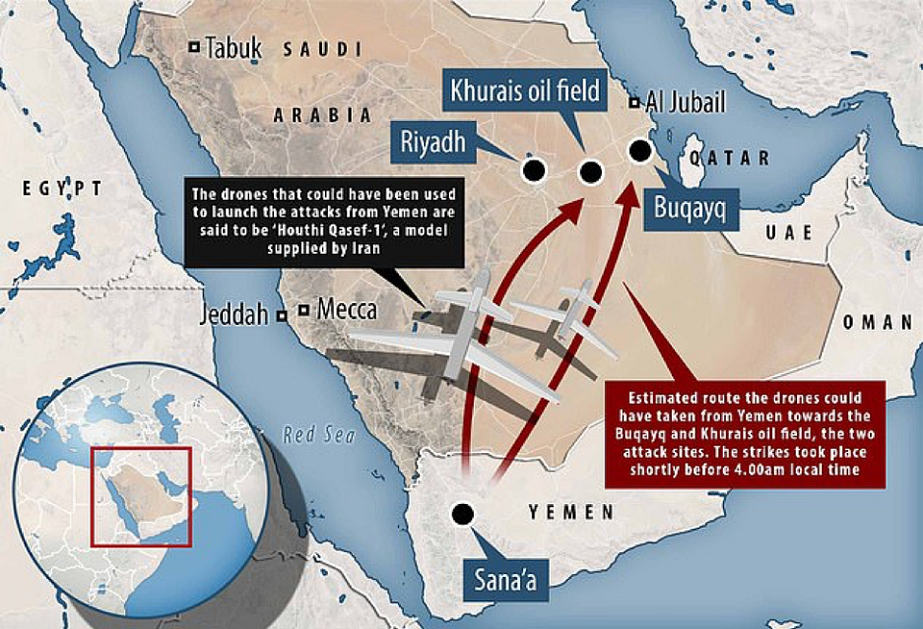
The missile strikes that badly damaged a key Saudi oil facility on Sept. 14, 2019 largely remain a mystery to the public.

Yemen's Houthi rebels, who have been at war with a Saudi-Emirati coalition since 2015, claimed responsibility for the coordinated attacks on two Saudi Aramco facilities, but it’s unclear that the Houthis alone possess the capacity for long-range, precision-guided strikes.

It’s possible the attacks involved far-flying drones firing small, guided munitions. The Aramco sites are around 800 miles from the Saudi Arabia-Yemen border. Iran’s hard-line Revolutionary Guard Corps in the past has supplied the Houthis with weaponry including drones and components for ballistic missiles.

But one thing is clear. The attack revealed the limits of Saudi Arabia’s seemingly sophisticated air-defense system. Riyadh in recent years has spent billions of dollars building up six battalions of U.S.-made Patriot surface-to-air missiles and associated radars. The Patriots didn’t stop the recent attack.

And it wasn’t the first time Saudi Arabia’s Patriots have failed. At least five Patriots apparently missed, malfunctioned or otherwise failed when Saudi forces tried to intercept a barrage of rockets targeting Riyadh on March 25, 2018.
 
Russia now bombs Ukraine with impunity targeting strategic power plants, gas plants, storage, etc Where are Patriots? Nowhere to be seen Here Is the report on failed interception in Saudi refinery

Why Did American Patriot Missiles Fail To Stop the Houthi's Attacks?​


And it wasn’t the first time Saudi Arabia’s Patriots have failed. At least five Patriots apparently missed, malfunctioned or otherwise failed when Saudi forces tried to intercept a barrage of rockets targeting Riyadh on March 25, 2018.

A refresher of how badly Patriot failed and failed and failed again


And as demonstrated so clearly in KSA the Aegis and Patriot systems defending Saudi a joke as the Aegis and Patriot cannot even detect a few sub Mach cruise missiles not to talk of taking them down. Even to now, no one sure where those came from and who flown them. Despite overlapping coverage of those Patriot and Aegis systems.

main-qimg-4288f77121353a50c0eca1fb240e5d3d


And now easy peasy and no sweat in taking out Mach 3 missiles effortlessly out of Ukraine sky
minions-laughing-rofl.gif


1708581729486.jpeg


1708581768980.jpeg


https%20_blogs-images.forbes.com_arielcohen_files_2019_09_Drone-attacks.jpg.png


The American systems dunno where the slow poke missiles came from and if missiles did not go off with bangs leaving smoke and fire, might not even have existed at all

ACF6896A-9846-4C11-AD6D-0B939F8792C4.jpg


New sales pitch? US makes the world’s ‘finest’ anti-air systems, but sometimes they just don’t work, Pompeo explains
Saudi air defenses like Patriot & Aegis don’t match their advertised properties, unfit for real combat – Russian Army (MAP)
 
The debate here reminds me of the debate 10 years ago when China used ballistic missiles to strike mobile aircraft carriers. Some of the technologies, guys, will really mature over time.
 
The debate here reminds me of the debate 10 years ago when China used ballistic missiles to strike mobile aircraft carriers. Some of the technologies, guys, will really mature over time.
Striking ships using ballistic missiles has been a thing for very long time.

Hitting planes at 2000 km is a snake oil for nothing can track targets at that distance.
 
Striking ships using ballistic missiles has been a thing for very long time.

Hitting planes at 2000 km is a snake oil for nothing can track targets at that distance.
Tracking by satellites is not snake oil even with today's technology. It will be better in the next 5-8 years. I'm not sure how shooting down a plane is possible when variables (position, height, speed, direction, etc.) will be different when the missile gets to the targeted airspace. I believe this could be a loitering missile similar to loitering munitions, except it's designed to crash into jets at much higher speed than the loitering munitions (basically, suicide drones). This could be used to execute a no-fly zone over or near Guam, if it ever comes into production.

Or, this is just a for-a-laugh article by SCMP.

So you will track planes using satellites? LOL!

Lets say somehow you do that in the day, what will you do at night? SAR wont work because of stealth and the fact that satellite has to move quite a bit to get enough synthetic aperture.

Okay since you do not know how shooting down air borne moving targets work. Here is a basic flow.

You detect a hostile using your scanning radars.
You track them using your scanning / firing solution radar. Tracking calculates its position, velocity (speed and direction).
You fire the missile with location you last found.
While missile is flying, you keep on tracking the target.
You update the new location of the target to missile using data link.
Eventually missile arrives near enough the target that it can use its own onboard radar to track the target and chase it. You do not need to provide any further updates.

Now, how will anyone track from 2000 KM away?
 
Last edited:
Striking ships using ballistic missiles has been a thing for very long time.

Hitting planes at 2000 km is a snake oil for nothing can track targets at that distance.
Well ever heard of over-the-horizon radar? With new algorithms, AI, and Supercomputer processing, The fidelity of OH radar improves considerably. Then you can add satellite or high-altitude HALE to confirm it


Over-the-Horizon radar (OTHR) uses ionospheric reflection to propagate HF transmissions to long range (~ 500 to 5000 km). The ionosphere is a dynamic “mirror” that varies diurnally, seasonally, and with the solar cycle. Geolocation of targets observed by OTHR, (Coordinate Registration; CR), requires accurate real-time ionospheric modeling and HF propagation calculations to convert radar-measured target signal delays and beam steers to geographical position.

Our team at NWRA is the developer of what is arguably the most sophisticated CR capability currently in existence, CREDO (Coordinate Registration Enhancement by Dynamic Optimization). CREDO uses OTHR vertical and oblique backscatter soundings to model the ionosphere by applying Tikhonov’s methodology for solving ill-posed problems (extended to multidimensional nonlinear inverse problems and optimized for fast numerical solution). This produces the smoothest ionosphere that agrees with input data within measurement error. More recently we developed a Tikhonov-based ionospheric data assimilation capability called GPSII (GPS Ionospheric Inversion; pronounced “gypsy”). GPSII is capable of ingesting data from GPS and LEO satellite beacons, in situ electron density (e.g., DMSP or CHAMP satellites), JASON altimeter, DORIS, and vertical incidence sounders. We propose to merge the CREDO and GPSII capabilities into a state-of-the-art OTHR CR capability and demonstrate resulting metric accuracy improvement. BENEFIT: The incorporation of additional ionospheric data beyond conventional OTHR vertical and oblique backscatter soundings is expected to improve the fidelity of real-time ionosphere models, resulting in improved OTHR Coordinate Registration metric accuracy. The Next Generation OTH Radar (NGOTHR) is expected to have the additional benefit of elevation information in its backscatter soundings, and this can be incorporated in our solution method for additional fidelity. Furthermore, because GPSII uses a non-radar-centric coordinate system, a single self-consistent ionosphere model can be developed for multiple OTH radars in the same region. This will result in consistent CR of targets in overlapping coverage areas and ensure smooth track continuity as targets move from one radar’s coverage to another. Improved CR metric accuracy will enhance the applicability of OTHR as a wide area surveillance asset for Air Force and Homeland Security applications with dramatic cost savings over alternative microwave radar solutions.
 
So you will track planes using satellites? LOL!

Lets say somehow you do that in the day, what will you do at night? SAR wont work because of stealth and the fact that satellite has to move quite a bit to get enough synthetic aperture.

Okay since you do not know how shooting down air borne moving targets work. Here is a basic flow.

You detect a hostile using your scanning radars.
You track them using your scanning / firing solution radar. Tracking calculates its position, velocity (speed and direction).
You fire the missile with location you last found.
While missile is flying, you keep on tracking the target.
You update the new location of the target to missile using data link.
Eventually missile arrives near enough the target that it can use its own onboard radar to track the target and chase it. You do not need to provide any further updates.

Now, how will anyone track from 2000 KM away?
REad this before dismissing it

Last fall, Army Gen. James Rainey warned that, “The ability to hide, which is fundamental to how we fight, is now impossible.” That was before China launched Yaogan-41.

China’s newest remote-sensing satellite ascended into geostationary orbit (GEO) on December 15, 2023. Yaogan-41, as it is called, can likely see, identify and track car-sized objects throughout the entire Indo-Pacific region. It’s an unprecedented capability that calls to mind the early 1980s pop-hit “Somebody’s Watching Me”.


It’s not clear whether Gen. Rainey, chief of the Army’s Futures Command, was aware of the impending launch of Yaogan-41 when he made the comment above but his assertion that Army (and other American) forces will be under constant surveillance in the future fits the current reality for military operations in the Indo-Pacific.

Clayton Swope, deputy director of the aerospace security project at the Washington DC-based Center for Strategic and International Studies (CSIS), has described Yaogan-41’s capabilities in a new essay entitled, “No Place to Hide”.

As Swope notes, China maintains that Yaogan-41 is a civilian high-altitude optical satellite intended for agricultural data gathering, weather forecasting, and disaster prevention.

But the country has routinely made such claims about remote-sensing satellites that are clearly intended for national security/military purposes.
Three of these (Gaofen-4, Gaofen-13, and Gaofen-13-02) are optical satellites that also view the Indo-Pacific from geosynchronous orbit. Their surveillance capabilities are believed to include optical resolution from 50 meters down to 15 meters. Yaogan-41 is believed to have resolution down to around 2.5 meters.
 
Well ever heard of over-the-horizon radar? With new algorithms, AI, and Supercomputer processing, The fidelity of OH radar improves considerably. Then you can add satellite or high-altitude HALE to confirm it
Over the horizon radars (OTH) are not good enough for tracking the targets. Actually, their detection capabilities are also limited to large maritime targets. This is because the wave length of radar waves used should be low enough that it is reflected by ionosphere. Even if they detect aircraft, they can not track them at low enough distance because of limitations mentioned above.

So no, you can not "add alrgorithms, supercomputer, AI (LOL!)" and suddenly make OTH a fire control radar. No amount of "alrgorithms, supercomputer, AI" can beat physics.
 
China’s newest remote-sensing satellite ascended into geostationary orbit (GEO) on December 15, 2023. Yaogan-41, as it is called, can likely see, identify and track car-sized objects throughout the entire Indo-Pacific region. It’s an unprecedented capability that calls to mind the early 1980s pop-hit “Somebody’s Watching Me”.
There is a difference in detecting and tracking a car and an airplane. And you have not even thought about the biggest issue. What will you do at night?
 
There is a difference in detecting and tracking a car and an airplane. And you have not even thought about the biggest issue. What will you do at night?
Ever heard of SAR Read this before commenting

Paired with its existing GEO optical surveillance capabilities, Yaogan-41's increased resolution means that China will be able to more easily identify and track U.S. and allied naval forces in the Indian and Pacific Oceans than it ever could before.

This increased resolution may give China the ability to identify and track even smaller objects, not just ships, but airborne assets like fighter aircraft and bombers as well. While stealth technology can help aircraft evade detection by radar, it is less effective against optical sensors, as demonstrated when a Google Maps user spotted a B-2 stealth bomber flying over Missouri. Pairing data from Yaogan-41 and China’s legacy GEO surveillance satellites with trained artificial intelligence (AI) algorithms would likely automate and speed up identifying objects of interest. For

Here is SAR satellite
In addition to these optical surveillance satellites, China operates one synthetic-aperture radar (SAR) satellite in GEO, called Ludi Tance-4 (Land Exploration-4 in English). Launched in August 2023, it is the world’s first and, currently, only GEO satellite with a SAR payload. The resolution of Ludi Tance-4 is 20 meters. The advantage of SAR is that it can see through clouds and at night. Like the three Gaofen satellites and Yaogan-41, China claims that the Ludi Tance-4’s mission is purely civilian and aimed at providing information about land resources, disaster prevention and response, and forestry applications.
 

Users who are viewing this thread

Back
Top