Iran - Israel/US War: Israel-US declare war on Iran, Iran responds

In international politics, when you are in a weak position, it is best to say less and do more.

The power of speech comes from your own hard power.
When your hard power is strong enough, you don't even need to speak; a glance is enough to strike fear into your opponents.
When your hard power is weak, no matter how hard you try to shout, no one will take your warnings seriously.

In the field of nuclear weapons, you either completely abandon nuclear weapons or you detonate one to show the world.

Iran has taken the most foolish approach. It constantly threatens the world that it will build nuclear weapons, but in reality, it has made no progress. Despite years of nuclear sanctions, it still does not possess nuclear weapons......
THAT'S WHAT I AM TRYING TO SAY!

I read some posts here, someone saying "next time, Jews won't be spared"

I am new here, I don't want to attack people and get banned, but seriously what the hell are you saying?!? When is next time???? Just shut up and focus on rebuilding the country.

With this attitude, they will continue bombing Iran until it looks like Afghanistan, and when the population is completely poor and destitute, these people will say "Well we are supposed to live like this, because capitalist lifestyle of wealth and success is haram" and then continue to say "we will punch America/Israel in the mouth" while Israelis and Americans bonk them on the head with a big stick again and again.
 
That was a PR move. You cannot take what Trump says as facts. There's no evidence that China asked Trump for permission to increase its oil purchase from Iran.

Because they have 24/7 satellite coverage with <5cm resolution. Do you seriously think they cannot find out if the uranium had been moved or not?
Do you remember the photo Trump posted a few years ago of a failed missile launch in Iran? The resolution was extremely good. So good that even fine prints on the missile could be read.


Agreed.
If we had a normal regime, Iran would've had a choice. But with this regime, I don't think so. Iran's nuclear adventures seem over at this point. I hope I'll be proven wrong soon, but it seems so.
I read the outline of initial nuclear offer to Iran. Money to help Iran build modern civilian reactors, guarantees of uranium for medical isotopes/ civilian energy. This may not look like much, but it would have helped Iran more than Iran staying a threshold state. Just sign an agreement and get wealthy and powerful. THEN YOU CAN DO WHAT YOU WANT.

I am starting to believe the Shah was doing this, and was slowly starting to turn against Israel. Some in Washington and Tel Aviv were probably breathing a sigh of relief when he was deposed.
 
Because they have 24/7 satellite coverage with <5cm resolution. Do you seriously think they cannot find out if the uranium had been moved or not?
Do you remember the photo Trump posted a few years ago of a failed missile launch in Iran? The resolution was extremely good. So good that even fine prints on the missile could be read.
Don't be fooled by this pseudo-scientific political propaganda.

To date, no country has the capability to conduct high-precision satellite surveillance of a specific region 24/7. The United States and China do indeed possess formidable satellite surveillance capabilities. However, they still have surveillance gaps.
 
I read the outline of initial nuclear offer to Iran. Money to help Iran build modern civilian reactors, guarantees of uranium for medical isotopes/ civilian energy. This may not look like much, but it would have helped Iran more than Iran staying a threshold state. Just sign an agreement and get wealthy and powerful. THEN YOU CAN DO WHAT YOU WANT.
They will never give Iran a fair, good deal. They said all of those things to give Iran some save facing reasons for destroying the IR-40 reactor.

Iran is no longer in a position to negotiate with the West. It's too late for that. Iran needs nuclear deterrence and needs to go down the paths of countries like China, Pakistan and even North Korea for a while. But the Ayatollahs are too corrupt to pursue such a path. How can you advocate for that in the IR regime when your Aghazadeh is living a luxurious life in the West? The system is too corrupt at this point. It has a revolutionary facade but in reality, it's an oligarchy-based regime with capitalist agendas.

I am starting to believe the Shah was doing this, and was slowly starting to turn against Israel. Some in Washington and Tel Aviv were probably breathing a sigh of relief when he was deposed.
Contrary to what some brain-dead people here say, the Shah was turning against the Jews. He even clearly talked about this in his interview with CNN, where he said that the Jewish lobby had too much power in the US.
His problem with Israel wasn't however an ideological one. He believed that the Israeli lobby was hindering Iran's growing military power by blocking Iran's requests for weapons from the US.
 
Don't be fooled by this pseudo-scientific political propaganda.

To date, no country has the capability to conduct high-precision satellite surveillance of a specific region 24/7. The United States and China do indeed possess formidable satellite surveillance capabilities. However, they still have surveillance gaps.
The US has nearly 10,000 LEO satellites expected to rise to 50K by 2035. I don't see why it's impossible for them to achieve nearly real-time extremely high resolution surveillance over a small region like central Iran.
 
They will never give Iran a fair, good deal. They said all of those things to give Iran some save facing reasons for destroying the IR-40 reactor.

Iran is no longer in a position to negotiate with the West. It's too late for that. Iran needs nuclear deterrence and needs to go down the paths of countries like China, Pakistan and even North Korea for a while. But the Ayatollahs are too corrupt to pursue such a path. How can you advocate for that in the IR regime when your Aghazadeh is living a luxurious life in the West? The system is too corrupt at this point. It has a revolutionary facade but in reality, it's an oligarchy-based regime with capitalist agendas.


Contrary to what some brain-dead people here say, the Shah was turning against the Jews. He even clearly talked about this in his interview with CNN, where he said that the Jewish lobby had too much power in the US.
His problem with Israel wasn't however an ideological one. He believed that the Israeli lobby was hindering Iran's growing military power by blocking Iran's requests for weapons from the US.
So... what now? Military coup?
 
So... what now? Military coup?
I have a feeling that we're heading towards the worst case scenario.

And the worst case scenario in my opinion is likely to be something like a new Saddam-style war with one of our neighbors or a coalition.
 
The US has nearly 10,000 LEO satellites expected to rise to 50K by 2035. I don't see why it's impossible for them to achieve nearly real-time extremely high resolution surveillance over a small region like central Iran.
This involves some specialized knowledge about artificial Earth satellites. I will try to answer your question in simple terms. You can look up more specialized knowledge on your own.

Artificial Earth satellites.
The higher its orbit, the closer it is to Earth's rotational speed. Therefore, its relative movement speed compared to a fixed location on the Earth's surface is slower.
When it is in GEO orbit (36,000 km), it is stationary relative to the Earth's surface.
When it is in LEO orbit (<2,000 km), it orbits the Earth approximately every 90 minutes.
The lower the orbit of an artificial satellite, the greater the gravitational pull it experiences from the Earth. As a result, it must constantly consume energy to maintain its orbital altitude. The corresponding result is that its lifespan is shorter.

Reconnaissance satellites require good reconnaissance capabilities. The lower their orbit, the better the performance of their reconnaissance equipment.

If we need to achieve 24/7 high-precision, seamless monitoring of a certain region over the long term, we need a huge monitoring network consisting of a large satellite constellation. Moreover, the satellites in the constellation need to be constantly updated.

If this is solely for military purposes, it is clearly a huge waste of funds.

Both the United States and China now have emergency satellite launch systems. When military purposes require it, a batch of military satellites can be launched through an emergency rapid launch mechanism. However, under normal circumstances, neither country's military has a large, seamless military reconnaissance satellite constellation on standby.

Jilin-1. It is civilian satellite. It monitors the entire globe, revisiting any location 35-37 times per day, with each visit lasting approximately 10 minutes. If the detector angle or satellite attitude is adjusted, the visit time can be increased to 20-30 minutes, but this consumes more energy. However, there are still gaps in its surveillance capabilities.
 
Captured! This is how the narrative is shaped. They create fake accounts that write extensively to promote their narrative. At the same time, they control all of the powerful governments in the West. The executive office, Congress, the majority of the courts, tech, and academia. It is the biblical prophecy happening right in front of the world.
 
Last edited:
This involves some specialized knowledge about artificial Earth satellites. I will try to answer your question in simple terms. You can look up more specialized knowledge on your own.

Artificial Earth satellites.
The higher its orbit, the closer it is to Earth's rotational speed. Therefore, its relative movement speed compared to a fixed location on the Earth's surface is slower.
When it is in GEO orbit (36,000 km), it is stationary relative to the Earth's surface.
When it is in LEO orbit (<2,000 km), it orbits the Earth approximately every 90 minutes.
The lower the orbit of an artificial satellite, the greater the gravitational pull it experiences from the Earth. As a result, it must constantly consume energy to maintain its orbital altitude. The corresponding result is that its lifespan is shorter.

Reconnaissance satellites require good reconnaissance capabilities. The lower their orbit, the better the performance of their reconnaissance equipment.

If we need to achieve 24/7 high-precision, seamless monitoring of a certain region over the long term, we need a huge monitoring network consisting of a large satellite constellation. Moreover, the satellites in the constellation need to be constantly updated.

If this is solely for military purposes, it is clearly a huge waste of funds.

Both the United States and China now have emergency satellite launch systems. When military purposes require it, a batch of military satellites can be launched through an emergency rapid launch mechanism. However, under normal circumstances, neither country's military has a large, seamless military reconnaissance satellite constellation on standby.

Currently, the largest surveillance satellite constellation in operation worldwide is “Jilin-1.” It is civilian satellite. It monitors the entire globe, revisiting any location 35-37 times per day, with each visit lasting approximately 10 minutes. If the detector angle or satellite attitude is adjusted, the visit time can be increased to 20-30 minutes, but this consumes more energy. However, there are still gaps in its surveillance capabilities.
Your answer is pretty basic and hardly goes beyond what is taught in high school physics in most countries.

If we use a 500km LEO satellite in a circular orbit as a baseline, it would pass 2-4 times over Iran every 24 hours. Its field of view would be enough to cover all of central Iran and each time it will be over Iran for about 10 minutes. So, in theory, you'll need fewer than 150 satellites in the orbit to achieve nearly real-time reconnaissance ability over most of Iran. I don't know about the Chinese capabilities, but the US has 10,000 LEO satellites. That's more than enough to achieve nearly real-time high-res reconnaissance.

The lifespan of LEO satellites is shorter mainly due to space debris, not because of energy issues in the orbit. If you achieve a perfect circular orbit, you don't experience much gravitational loss of energy because W = F.d and the gravitational pull towards the center is perpendicular to the movement of the satellite (tangential).
 
Your answer is pretty basic and hardly goes beyond what is taught in high school physics in most countries.

If we use a 500km LEO satellite in a circular orbit as a baseline, it would pass 2-4 times over Iran every 24 hours. Its field of view would be enough to cover all of central Iran and each time it will be over Iran for about 10 minutes. So, in theory, you'll need fewer than 150 satellites in the orbit to achieve nearly real-time reconnaissance ability over most of Iran. I don't know about the Chinese capabilities, but the US has 10,000 LEO satellites. That's more than enough to achieve nearly real-time high-res reconnaissance.

The lifespan of LEO satellites is shorter mainly due to space debris, not because of energy issues in the orbit. If you achieve a perfect circular orbit, you don't experience much gravitational loss of energy because W = F.d and the gravitational pull towards the center is perpendicular to the movement of the satellite (tangential).
Even if this were true, send 20 trucks to Fordo. Then send them all in different directions. Do you think they will be able to pinpoint which truck has the uranium via satellite?
 
Even if this were true, send 20 trucks to Fordo. Then send them all in different directions. Do you think they will be able to pinpoint which truck has the uranium via satellite?
Assume that their time resolution is under 5 minutes. I don't see why it should be impossible to do. How much does a loaded truck travel in 5 minutes? 5km? 8km? Assuming a speed of 60km/h to 100km/h. It's not that far to lose track, is it?

They also had surveillance drones over Iran. We did shoot down a couple of them, but how many did we fail to shoot down? I guess we'll never know.

The point is that you cannot just load 15,000 centrifuges, 408 kg of 60% enriched uranium + tones of lower-enriched uranium stockpile and completely evade all kinds of detection.
 
Your answer is pretty basic and hardly goes beyond what is taught in high school physics in most countries.

If we use a 500km LEO satellite in a circular orbit as a baseline, it would pass 2-4 times over Iran every 24 hours. Its field of view would be enough to cover all of central Iran and each time it will be over Iran for about 10 minutes. So, in theory, you'll need fewer than 150 satellites in the orbit to achieve nearly real-time reconnaissance ability over most of Iran. I don't know about the Chinese capabilities, but the US has 10,000 LEO satellites. That's more than enough to achieve nearly real-time high-res reconnaissance.

The lifespan of LEO satellites is shorter mainly due to space debris, not because of energy issues in the orbit. If you achieve a perfect circular orbit, you don't experience much gravitational loss of energy because W = F.d and the gravitational pull towards the center is perpendicular to the movement of the satellite (tangential).
1. Not all LEO satellites are remote sensing satellites (optical reconnaissance satellites are a type of remote sensing satellite). Optical reconnaissance satellites are only a small part of them.

2. Large remote sensing satellite constellations are public information worldwide. No country can hide this information. The United States/Russia/China. They can hide a specific-purpose satellite or spacecraft, but they cannot hide a large remote sensing satellite constellation.
It is known that Jilin-1 is currently the largest remote sensing satellite constellation in the world. It currently has over 130 satellites in orbit, with more still being launched. The constellation is planned to reach over 300 satellites in orbit.

3. The daily data volume generated by large remote sensing satellite constellations is staggering. If all the data were downloaded to the ground for analysis, it would severely clog communication channels. China has already launched computing satellites into space. This data will be processed and analyzed directly in space. The final results will be transmitted back to ground receiving stations.

This is a video of the “Jilin-1” smart surveillance system monitoring Atlanta Airport in the United States. You can assess its capabilities for yourself.
 
Last edited:
Your answer is pretty basic and hardly goes beyond what is taught in high school physics in most countries.

If we use a 500km LEO satellite in a circular orbit as a baseline, it would pass 2-4 times over Iran every 24 hours. Its field of view would be enough to cover all of central Iran and each time it will be over Iran for about 10 minutes. So, in theory, you'll need fewer than 150 satellites in the orbit to achieve nearly real-time reconnaissance ability over most of Iran. I don't know about the Chinese capabilities, but the US has 10,000 LEO satellites. That's more than enough to achieve nearly real-time high-res reconnaissance.

The lifespan of LEO satellites is shorter mainly due to space debris, not because of energy issues in the orbit. If you achieve a perfect circular orbit, you don't experience much gravitational loss of energy because W = F.d and the gravitational pull towards the center is perpendicular to the movement of the satellite (tangential).
What is your field of study?

Btw, to achieve temporal resolution, deploying multiple satellites into a constellation could be a great solution but it will be too expensive, depending on your demand. Geo-stationary satellites lack high spatial resolution but are highly survivable due to much less attrition.

Jews will pay for every penny of LEO sats to achieve their desired real time data from Iran.
 
1. Not all LEO satellites are remote sensing satellites (optical reconnaissance satellites are a type of remote sensing satellite). Optical reconnaissance satellites are only a small part of them.

2. Large remote sensing satellite constellations are public information worldwide. No country can hide this information. The United States/Russia/China. They can hide a specific-purpose satellite or spacecraft, but they cannot hide a large remote sensing satellite constellation.
It is known that Jilin-1 is currently the largest remote sensing satellite constellation in the world. It currently has over 130 satellites in orbit, with more still being launched. The constellation is planned to reach over 300 satellites in orbit.

3. The daily data volume generated by large remote sensing satellite constellations is staggering. If all the data were downloaded to the ground for analysis, it would severely clog communication channels. China has already launched computing satellites into space. This data will be processed and analyzed directly in space. The final results will be transmitted back to ground receiving stations.
Sure, I didn't claim all of those 10K satellites were used for reconnaissance, did I?

Also, remember that the US is not alone. Every satellite launched by the US, Israel, France, the UK, or any other country with decent reconnaissance abilities can and will be used against Iran. Why do you think the US had something like MET in Qatar to relay information to Israel and NATO?

The US has tremendous amount of processing power. Its processing power is already estimated at 100-120 ExaFLOPS. They already have super computers that have reached +5 ExaFLOPS. Didn't you see how they tracked Iranian military generals using the data they collected through social apps, smart phones, etc.?

The problem of continuous coverage of reconnaissance constellations is something that has been thoroughly studied. I did ask AI to find me some evidence for my initial estimate that 150 satellites would be enough to reach nearly real-time coverage over Iran. It turns out that both copilot and ChatGPT agreed with me that achieving under 5 minutes revisit time with 150 satellites is absolutely possible.

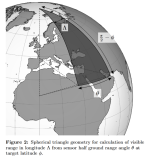
Copilot even gave me some article on Arxiv that discusses the same problem. Ironically enough, the image they use to set up their geometric equations focuses on the Middle East. An interesting coincidence.
1755919130711.png
On top of all this, remember that both the US and Israel were flying reconnaissance drones near and even over some regions of Iran.
 

Users who are viewing this thread

Country Watch Latest

Back
Top